Yosemite Vogelsang Loop 2021

I have wanted to backpack this particular loop since the late 90's, but didn't have the opportunity. Also, my concerns about crowds and quota hassles at Yosemite National Park and kept me from pursuing this area. To my surprise, I was able to obtain a wilderness permit relatively easily, and I saw fewer people on the trail than I had expected within this popular area. Even during times of Covid, when permit applications were at an all-time high, the weekday solitude on the trail and in the campsites was a real gift.

Location (Red icon) of Vogelsang Trailhead in Tuolumne Meadows, Yosemite National Park, California


Approximated GPX Track of my clockwise loop route. (My actual route was lost during a computer crash so route shown is approximated on Gaia GPS.)
Total Distance: 30 Miles (48 Km) Elevation Ascent: 5071 feet
Arrival in Yosemite National Park: As the day for the trip approached, I had been anxiously watching the snow levels closely using Gaia GPS. Although it was late June, the hot climate and the previous winter's low snowfall meant that the trails were quite empty of snow. I drove to Yosemite from the San Francisco Bay area, arriving mid-day. Although I had planned to stay the night before my trip in the Backpacker's camp at Tuolumne Meadows, I learned that the campground didn't open for the season until the very next day! After obtaining my permit, I drove east to seek a campground not too far away where I could camp for the night. Fortunately, the crowds were not too bad and I was able to get a small drive-in tent site at the Lake Tioga National Forest Service campground - the last site available. The weather was perfect and I enjoyed a relaxing afternoon at the lake taking photographs.


Day 1: Tuolumne Meadows Trailhead to Vogelsang Backpackers Camp: 7.5 miles - 12 km
After a quick stop to store a few car items in the bear-proof lockers, I set out from the Trailhead at the eastern parking area of Tuolumne Meadows. I was on the trail by 8:45 a.m. and it was a beautiful day, warm enough to work up a sweat in shirtsleeves on the gentle uphill. I saw few people on the trail, but did meet a ranger who asked for my permit and confirmed that I was carrying a bear can for food storage. Along the way I saw my first signs of many trees turning brown, or with brown new growth at the tips. I learned later this was due to the prolonged drought in the state -- terribly sad to see!


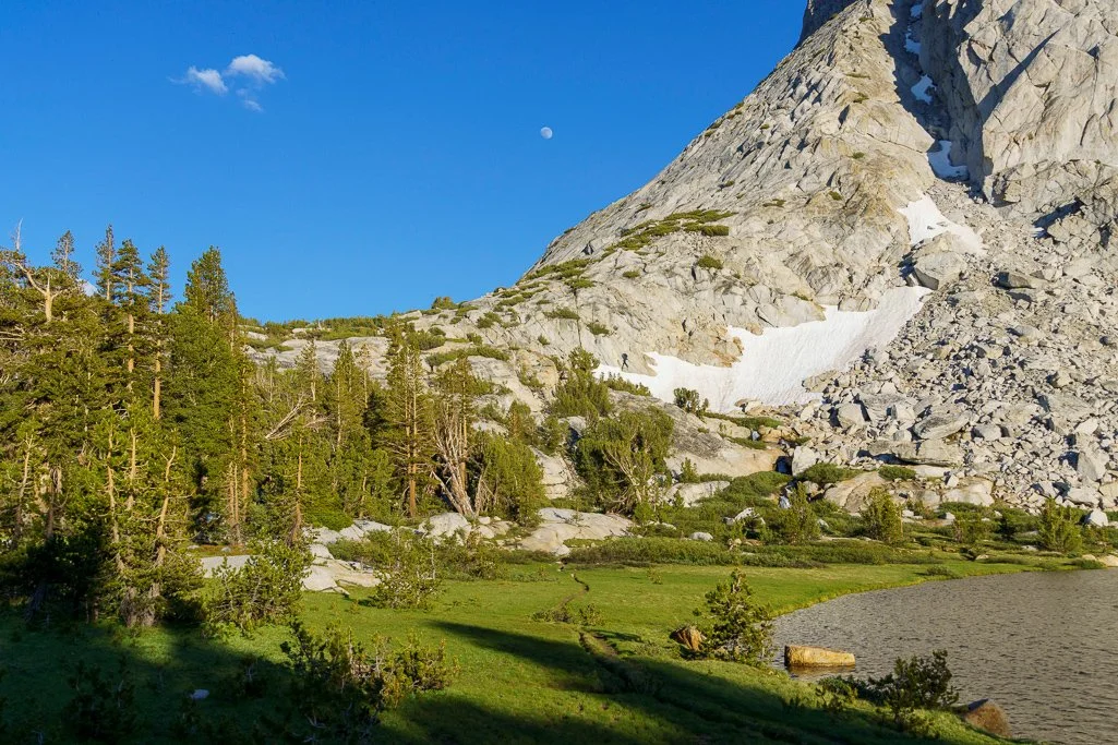
As I neared Tuolumne Pass, the mountain ranges to the south became visible, and the air was noticeably cooler. The Vogelsang High Sierra camp was closed this year, and partially dismantled. I headed for the backpacker's area and found a nice isolated spot on the far northeastern boundary. To my surprise, there were only two other people in the entire campsite area! There were also large food storage lockers nearby in a central area of the backpacker's area. As I was walking around to explore the area, I met a young man carrying two backpacks who appeared tired and concerned. Apparently his girlfriend was suffering from food poisoning, and they had hiked all the way from Lake Merced that day, trying to get out of the wilderness. They still had another 8 miles to go, and he reported that she was still sick and dehydrated. There was no ranger, but he did drop his girlfriend's pack in the bear locker for later retrieval, so that they could have an easier hike out that afternoon. I did not envy them their long, challenging hike under such difficult conditions! I offered to text him any relevant info on my Inreach if the ranger showed up, and he set off to shepherd her back to the trailhead. What a shame to have such a bad experience in this spectacular environment. I explored Lake Fletcher a bit, but the sun was quite bright for photography. I resolved to allow enough time in the morning for more exploration.


Day 2: Vogelsang Backpackers Camp to Vogelsang Pass and Lewis Creek: 5.5 miles/8.9 km
I slept poorly, awoke early, and went back to sleep, knowing I was planning on a low-mileage day with extra time to sight-see. Before breakfast, I went to see if the ranger had appeared so I could tell them about the couple's abandoned pack in the lockers. The ranger wasn't present, but I took some time to photograph the lake in the still-bright morning light.


After a leisurely breakfast and packing up, I headed toward Lake Vogelsang and Vogelsang Pass. It was very windy and quite cool as I gradually climbed. Cresting a rise, I could see Lake Vogelsang in the distance, and reached its rocky shore not long thereafter.


After hiking around the windswept lake, I continued climbing. I kept thinking I was at the pass, only to find a little bit more to climb.


Finally, I reached the summit and could see Gallison and Bernice Lakes below, on the left and right, respectively.

The view down into the Valley was impressive!
I began the descent down multiple switchbacks, passing a few small streams that were the outlet of Gallison Lake, and enjoying the warmer and less windy climate on the other side of the pass. I stopped to watch a Clark's Nutcracker, and could see Lewis Creek flowing south in the valley below.


Lewis Creek wasn't very high, but it was high enough to require log-hopping to get across.

This was a beautiful little spot to stop to enjoy the surroundings.
Near the outlet of Florence Lake was a small campsite reported in a guidebook, where I planned to spend the night. The outlet flowed down granite walls just to the east of the creek, and the creek crossing was sketchy enough to make me pack up my camera in a waterproof bag. I decided to cross the creek in the morning and look for the campsite. I found two in the woods; one was on a high cliff that got more sun, and the second deeper in the woods in a tree-filled meadow. I set up my tent on the cliff and ate in the meadow site, enjoying the solitude. I hadn't seen another soul all day since I left Vogelsang Backpacker's Camp!


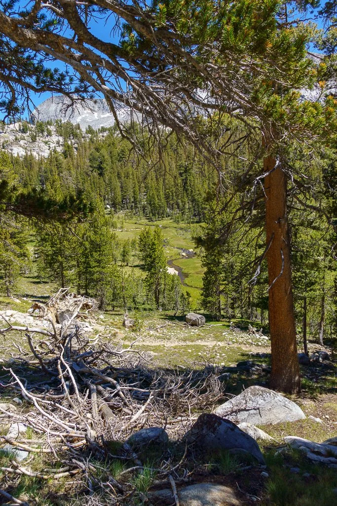
Day 3: Lewis Creek to Emeric Lake: 7.8 miles - 12.6 km After a solid night's sleep, I felt much better the next day. The creek crossing was uneventful, although I did secure my camera inside my pack in a waterproof bag first. It was a warm, bright day requiring extra sunscreen. After a short while, I could see Lake Merced far below through the trees. Just above the confluence of Fletcher and Lewis creeks, I turned north toward Babcock and Emeric Lakes, crossing a small footbridge over the now much broader Fletcher Creek.


Shortly after the creek crossing, I began a more steep ascent of about a mile, up carefully constructed granite cobblestone steps. It was, as described in a guidebook, "a bit of a grunt on a hot day." The trail was beautifully constructed and interspersed with giant Western Juniper trees, shedding their berries. I had to admire the amount of work required to construct all the steps on the trail. As I climbed, the view of the western range expanded, and I could stop to appreciate Fletcher Creek cascading over the granite. Once past the steeper part of the ascent, the trail leveled out, passing beautiful stands of exfoliating granite.


Soon, I came upon the outlet of Lake Emeric, flowing down granite faces to meet with Fletcher Creek. In these past years of drought, the flow was small, and one could probably hop across the wet granite to approach Emeric Lake from the south. However, I took the conservative route to the trail junction to the north, adding a bit of extra mileage. Finally reaching Lake Emeric, I took the trail on the eastern side of the lake until it petered out, before exploring the northern and western sides. The best campsites were on the western side of the lake, and quite spread out for maximum privacy. I discovered to my surprise that I had the entire lake to myself -- what a treat!
Lake Emeric Slideshow


Day 4: Emeric Lake to Trailhead: 11 miles - 17.7 km I slept poorly again, but instead of tossing and turning when I awoke before midnight, I had fun taking a few photos of Emeric Lake by the nearly full moon. I need more practice at taking and processing these photos! It was much cooler here than at the previous campsites.

I was up fairly early, but the bugs were so heavy by the lake that I didn't linger for photos. My plan was to hike back to the trailhead and drive home, so it was worth an earlier start. I took the western trail back to Tuolumne Pass, which was a pleasant leisurely hike, dotted with a few small lakelets, and a view of Boothe Lake to the west.


Towards the afternoon, I began to see more backpackers toiling up toward Tuolumne Pass, and I was glad I had chosen a weekday trip. The clouds darkened in the afternoon, and within a couple miles of the trailhead, a few drops of rain began spattering down. The rain was fairly light though, and I made it back to the trailhead without getting too wet. Another delightful backpacking trip!
I highly recommend this loop excursion in Yosemite National Park. I do worry about the obvious effect of the drought on the forest, and can only hope this improves in coming seasons. I was surprised to experience so much solitude in Yosemite, but the ranger said that isn't uncommon on weekday excursions. The scenery on this trip is excellent for the minimal challenge, especially if you choose to break up the trip into small sections as I did. I learned from a ranger that applications for wilderness permits were much higher in 2021 than pre-pandemic, yet I was still able to enjoy solitude. Whether that changes as European visitors return to Yosemite remains to be seen. Nevertheless, based on this trip, my years of avoiding Yosemite because of crowd worries are over! I look forward to exploring some of the areas I haven't seen in the park, in upcoming trips.
Photos by Cris Lewis; Sony Alpha 6600, 18-135 mm Sony lens.
LOGISTICS
Wilderness Permit reservations for Yosemite National Park are available 6 months in advance, or up to 7 days in advance where openings exist.
I saw no bears on the entire trip, and deer were the only large mammals I observed. Bear-proof containers are absolutely required, and rangers are actively patrolling the trails to check permits and confirm bear-proof containers. I was happy to see this, to ensure bear safety in the face of National Park visitors. The trails were all in excellent shape and well-maintained.
Check before you go to ensure the backpacker's camp is open, and to double-check fire / snow / weather conditions if need be. The backpacker's camp is hike-in only, although one can drop gear and then move a vehicle to potential parking on Tuolumne road.
I had treated my clothing with Permethrin spray prior to this trip, and it certainly seemed to work. In spite of the heavy bugs at Emeric Lake on Thursday morning, I experienced few bites.