SOUTH VANCOUVER ISLAND
TOFINO AND BROKEN GROUP 2015

In the summer of 2015 I had the wonderful opportunity to paddle with friends in southwest Vancouver Island, among the islands north of Tofino, and then in the Broken Group Islands. This was planned to be a low-key trip, with low-mileage paddling and non-paddling days added to allow time to explore and do some hiking. I found that the Broken Group Islands were much more popular for kayak campers than further north on Vancouver Island, and vastly more popular than Alaska locations. Nonetheless, these were beautiful, unspoiled locations with plenty of wildlife and beautiful vistas. It was a very enjoyable and relaxing kayaking trip with great paddling companions.
North of Tofino

GPS Track out and back from Tofino, visiting Vargas and Flores Islands, and a few others along the way.
Four paddlers (Doug, Gordon, Don and myself) drove from the San Francisco Bay area in two cars across the U.S.-Canada border and into Tsawassen, where we caught the ferry to Nanaimo on Vancouver Island. Once in Nanaimo, we stayed at a great location close to the ferry - the Living Forest Campground, where we had reservations. This was a large but quiet campground with nice amenities, and some sites on the water. The next day, we drove to Tofino, a popular surfing location on the south west coast of Vancouver Island. After time to unload and gather some last supplies, we launched around 3:30 in the afternoon and paddled north to Ahous Bay. The conditions were great, allowing for relaxed exploring along the coast, about 6.6 miles. The campsite here, like many on coastal Vancouver Island, was well maintained, with bear storage, a composting toilet, and a wonderful beach.
Day 2: Day Paddle out of Ahous Bay to Cleland Ecological Preserve and Blunden Island -- 10.6 mi / 17 km. The next morning, I had time for a short hike before breakfast, and enjoyed the quiet beach. The winds were forecast to be quite high in the afternoon, so we had a fairly short but delightful day paddle out to Blunden Island and the Cleland Island Ecological Reserve, as well as the neighboring islets. We saw lots of sea otters, and some huge Steller sea lions on Plover Reef in the Reserve. As the winds picked up, we headed back, and were later treated to a wonderful sunset.

A quiet morning on Ahous Bay


A lone sunflower on the beach

Sunset on Ahous Bay
Day 3,4,5: Ahous Bay to Cow Bay, Flores Island -- 9.6 mi / 15.4 km We launched around mid-morning and paddled north toward Flores Island. There were some reflecting waves along the southwest shore of Flores, and the afternoon winds were beginning to pick up as we tucked through a passage in the rocks and into the southwest corner of Cow Bay. There was another nice campsite at this beach, with three platform tent pads and an open cooking area. There were only three other people in this area, plenty of room on such a large beach. We spied some probable wolf tracks in the sand; they are a known to be present on these islands. Once again, we enjoyed a nice sunset after dinner.


With a designated exploration day, we set off to hike the Wild Side trail, aptly named as it included lots of ups and downs and rooty obstacles. I stopped to sign a geocache on the point, then caught up with the others for a relaxing lunch on the beach at Whitesands Cove. We opted for the shorter hike back with a high tide shortcut trail back to our campsite. The trail was not steep but made for challenging footing for more than 5 miles -- there is a reason the Vancouver Island hiking trails are rated as difficult! We spied a few bear and wolf prints along the way, as the fog wafted in and out.
Flores Island Slideshow
Flores Island Slideshow

Trail map for the Marine Park on Flores Island


It was quite foggy as we set out on our hike.
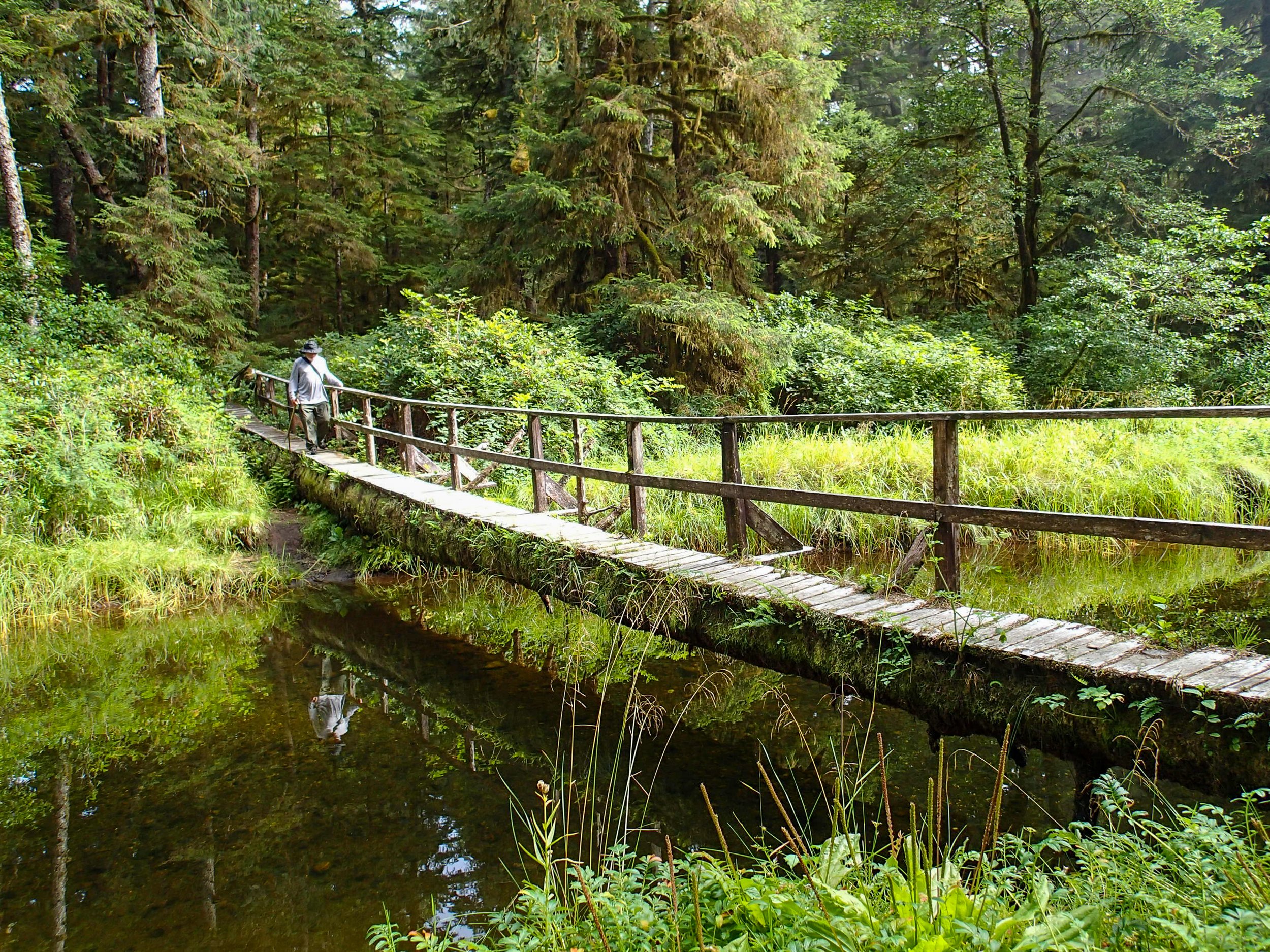
The bridge on the trail

This little campsite was well hidden from view. Someone left a tarp cover, and I moved in after the first night.

A beautiful beach seascape

Another jaw-dropping sunset. Colors are as photographed!

Near the west end of Cow Bay

There wasn't much swell, in spite of the windy forecast.
The weather forecast included 20-30 knot winds the next day, so we opted to sleep in and explore the island to the west, rather than do the longegr paddle back to Tofino in poor weather. It was cold and foggy, and we set off following some wolf prints to the western side of the island. This was a beautiful stretch of isolated beach, great for exploring.
Day 6: Cow Bay to Tofino -- 15.5 mi / 25 km The next morning we packed up to paddle back to Tofino. We took the northern route back, stopping for lunch on the north of Vargas Island. We arrived back in Tofino before 3 p.m. and spent some time unloading the kayaks and loading up the vehicles. We departed south for Ucluelet campground where we were lucky enough to secure the last campsites. This was a nice campground and RV park, and the hot showers were welcome!
The Broken Group

Partial GPS track of our paddle in the Broken Group of Islands. The route from initial launch and part of the 12th day was not captured, nor was the return paddle from Turret Island back to Toquart Beach.
Day 7,8: Toquart Bay Secret Beach Launch to Hand Island: ~ 5 mi / 8 km
The next morning we had plenty of time to go out to breakfast, get water refills and pick up our permits for camping in the Broken Group. After driving to Toquart Bay to unload the boats, pay launch fees, and park, we launched around 1 in the afternoon in good weather, heading for Hand Island. We had the campsite on the east facing beach of Hand Island all to ourselves; it was a nice site with privies and good tent sites. The next day we paddled a short distance northeast, as some in our party wanted to stop at Sechart lodge for a hot lunch and cold beer during a sightseeing paddle.


Canadian map of the Broken Group Islands showing approved campsites. The northern portion is on the left, the southwestern portion on the right.
Day 9: Hand Island to Gilbert Island and Effingham Island - 12.2 mi / 19.6 mi We packed up and moved camp from Hand Island, paddling to Dodd Island, which was quite crowded. We continued paddling to Gilbert Island, which was also busy, but we were able to find some space. After setting up our tents and dropping some gear, we went for a nice day paddle circumnavigating Effingham Island.

Perfect weather in the islands!

Paddling through the arch in Effingham Island
Day 10: Outer Islands Tour of Broken Group -- 9.9 mi / 15.9 km I was excited to paddle out to the outer islands of the Broken Group the next day. There was already a breeze as we departed mid-morning, and we paddled northwest to Clarke and then Benson Islands. As we hit the open coast, the wind had increased and the seas were confused with reflecting waves. As we paddled back southeast toward Wouwer Island, the wind increased to ~ 20 knots with higher gusts. The seas built to 1-2 meters wind waves, and I learned that an empty Prijon Kodiak is not nearly as stable as a loaded one! We landed on Wouwer beach and walked to across a tidal channel to a warm sunny beach on the leeward side, for some relaxation and lunch.

We tied up for a lunch break and some protection from the wind on a protected cove on Wouwer Island.
After lunch, we paddled / surfed the wind waves back to Gilbert Island, hitting some nice speeds! At camp in the late afternoon, we bundled up and watched the wind, which eventually calmed around 7:30 p.m. We enjoyed another peaceful evening on the island, with great views.

Day 11: Outer Islands Tour of Broken Group -- 12.3 mi / 19.8 km Along the way, we had picked up some notes from a fellow traveler that illustrated some highlights of the trip on a map (see below). We set out to explore more of the outer coast islands again, this time paddling southeast next to Effingham before turning southwest to paddle along the outer coast of Cree Island. We stopped at the 'Great Tide Pool' on Wouwer Island where we explored for a bit, and I spied a little mink. We then paddled to Dice Box Island and landed, where we hiked over a hill to an old fortified village. After returning to Gilbert Island for lunch, we paddled over to explore Effingham Island more thoroughly. After visiting several of the coves, we finally found the trail we had been told about, which crossed part of the island to a beach on the eastern side. The trail was fairly thick, but not as bad as some Alaskan 'trails.' The beach on the east side was peaceful and strewn with logs. Along the way, we saw some magnificent old growth cedar trees and other interesting flora and fauna.
Island Exploration

The elusive trail eventually led to an eastern beach on Effingham Island

A caterpillar I hadn't seen before, perhaps a tiger moth.

An interesting mushroom, perhaps a hemlock varnish shelf.

Old growth cedar


Day 12: Gilbert Island to Turret Island, Lovett, Puffin & Clarke Islands -- ~ 7.5 mi / 12 km We packed up to depart Gilbert, heading for Turret Island around mid-morning. We found only one couple and their young child at Turret, and we landed and set up tents. Thirty minutes later, a group of more than ten people arrived! We went for an afternoon paddle out around Puffin and Lovett Islets, and around Clarke Island again, before returning to Turret Island. Back on Turret Island, we found the short easy trail to the giant cedars and took some photos. I had time to relax in the sunshine in the afternoon - camping bliss!

Day 13: Turret Island back to Toquart Bay -- ~ 9 mi / 14.5 km
At dawn I was treated to a beautiful view just outside my tent. It was time to pack up and head back to civilization. The paddle back to Toquart Bay was in perfect weather, and we had plenty of time to load up kayaks and gear before starting the long drive back home.

This was just the sea kayaking trip I needed this year -- very relaxing and with great company. The weather was quite favorable on this trip, which made it that much more special. The sunsets were spectacular, and the wildlife was plentiful, if elusive. All of these islands offer great kayaking destinations, with mostly protected waters and well managed camping sites. Indeed, the presence of bear lockers and outhouses at most locations makes it close to glamping. On the other hand, given their proximity to civilization and relatively benign paddling conditions, both areas were more crowded than areas in northwestern Vancouver Island, and in Alaska. Nevertheless, this area makes for a mellow and relaxing kayaking vacation, and there are plenty of areas to explore on land as well.
LOGISTICS AND INFORMATION
Photographs by Cris Lewis, Olympus TG-2
The Living Forest Campground is very convenient to the Nanaimo ferry terminal, and is large and well tended, but does require reservations. It also has limited wi-fi.
In the town of Tofino, there is a store with kayaking gear, and free parking in the center of town (in 2015). This requires one to unload and then park, but the distance is a fairly short walk. The launch ramp is small but not busy.
The Ucluelet campground is a convenient place to stay when exploring the area. They are busy in the summer and reservations are strongly recommended.
Camping in The Broken Group requires advanced reservation permits, and reservations can be made here; As indicated on the map above, camping is permitted only in designated sites, and the area is patrolled for compliance.
The Secret Beach Campground offers a convenient kayak launch.
Coordinates for some locations are below: Note that some camping locations may move as part of park management in Canada.
Toquart Secret Beach Launch spot: N49 00.242 W125 22.059
Hand Island campsite: N48 57.062 W125 18.617
Dodd Island campsite used N48 55.307 W125 19.376
Gilbert Island campsite: N48 52.524 W125 19.230
Turret Island campsite: N48 54.237 W125 20.935
A map of The Broken Group with notes of highlights to visit is below:

