Grand Canyon of the Tuolumne 2022

The Grand Canyon of the Tuolumne is an iconic hike that I wanted to tackle in the height of summer. I was fortunate to get a mid-week permit and decided to do a 1-way shuttle hike from Tuolumne Meadows to White Wolf Lodge, with a ticket to catch the YARTS Shuttle bus back to Tuolumne after my trip. I purposely allowed myself four nights for a very leisurely pace, as I knew I wanted to take photos and spend extra time enjoying the surroundings, plus avoid having to drive home late at night. I had studied and debated my options, but ultimately chose to take the less commonly used east to west route. It had its advantages, and I was happy with my choice, almost! There was yet another wildfire burning northwest of the area, and I hoped it would soon be under control. It was hot, but the weather was perfect. The transportation plan, not so much.

Location (Red icon) of Tuolumne Meadows Trailhead in Tuolumne Meadows, Yosemite National Park, California


GPS Track of my East to West route
Total Distance: 39.5 Miles (63.6 Km)
Arrival in Yosemite National Park: Because the Tuolumne Meadows Campground was closed for the season, and I had a long drive from the Bay area, I collected my permit the day before my hike, and then camped at the Mono Vista RV Park in Lee Vining. Their campground was full, so I was glad I had made reservations. This allowed me to get an early start the next morning.
Day 1: Tuolumne Meadows Trailhead to Tuolumne River: 8.1 miles - 13 km
I parked my car in the Tuolumne parking area and crossed the street to begin the trip. It was a bright and sunny July day, and I didn't linger in Tuolumne Meadows, instead opting to head directly to the main trail.

I spied a marmot sunning himself on a rock, and one lounging by the shore of the Tuolumne River. At this beginning of the trail, the Tuolumne is moving lazily, with no hint of it's powerful descent.


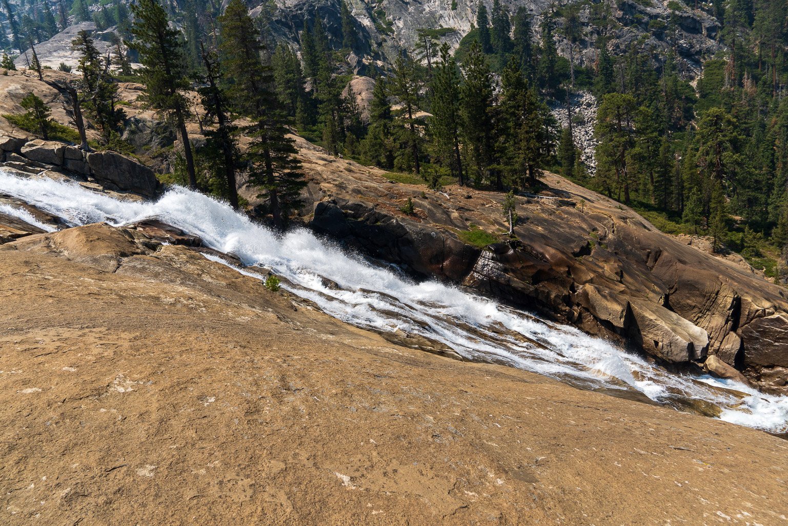
The first waterfalls began before 4 miles in, and were a delightful sight all the rest of the day; each with it's own power and magical setting. I reached my targeted stopping point in the early afternoon, and found a beautiful, small established site somewhat secluded from the larger area. After setting up camp, I experimented with photographing the waterfalls with a neutral density and circular polarizer filter. I had debated bringing my tripod, but decided at the last minute to leave it, to save the weight. I found I could improvise with rocks and natural props even for long-exposure photos, a valuable learning experience.
I met Emily, very nice solo female hiker who had been camped nearby for a few days, and we had a chance to chat in the evening.


Day 2: Tuolumne River Camp 1 to Cathedral Creek Falls area: 8.6 miles - 13.8 km
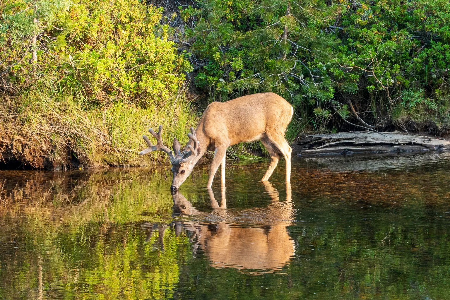
In the morning, I was up early but not in a hurry to leave this beautiful site. My camping neighbor came over with her coffee and we watched a beautiful buck drink from the river. When he daintily squatted to urinate, we laughed quietly and said, "Ah, yes, this is why we purify our water!"

The day's hike was another spectacular and easy downhill hike past the iconic California, LeConte, and Waterwheel Falls, plus a few smaller ones, where I stopped to capture photos. Just seeing the pristine river flowing through the rocks and trees was a constant delight.


After passing Cathedral Creek Falls, I started looking for a camping spot in the mid-afternoon. Most of the good spots along this stretch were taken, so that the only spots available were just off the trail in a dry spot with no shade. After scouting ahead, I decided to turn back and make the best of this site. It was very hot, and I made the most of any shade I could find. I rinsed off in an offshoot of the river a few times, and was happy when the sun started to set.
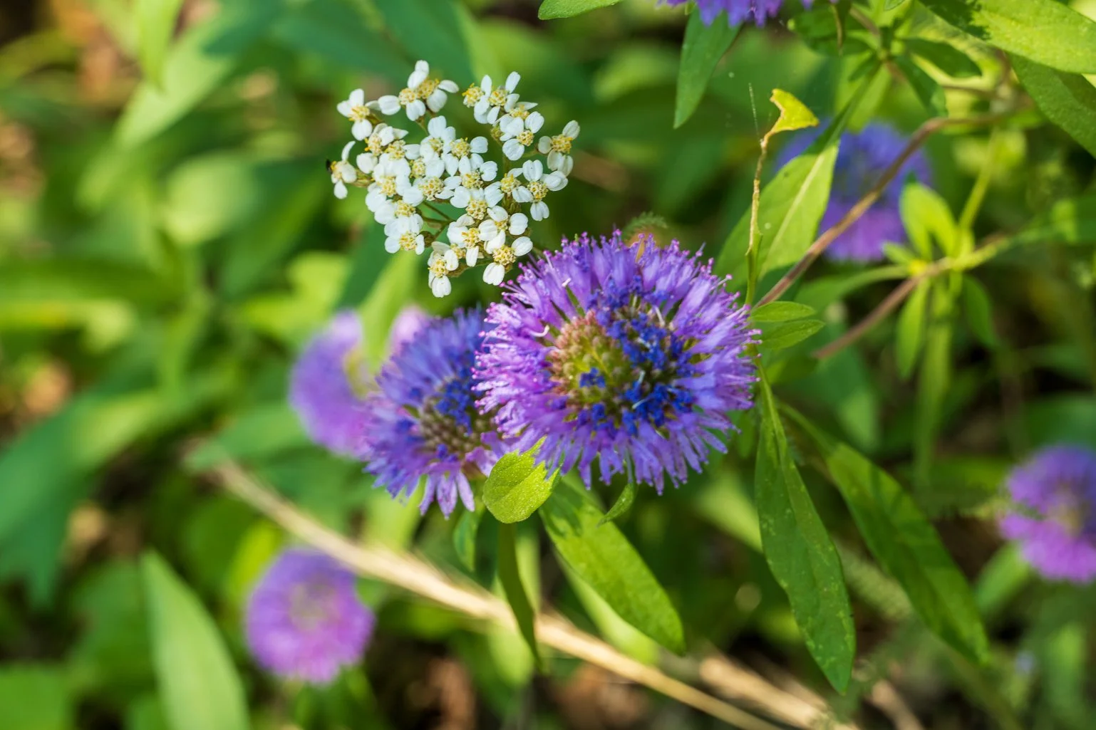
Wildflowers Along the Trail

Day 3: Cathedral Falls area to Pate Valley: 7.1 miles - 11.4 km
This part of the trek included a short uphill, as the trail went north up into the mountains as it skirted some of the steep, sheer walls of Muir Gorge. The trail was rocky and twisty, with only a few views of the gorge far below.

Near Register Creek, there was an interesting tall canyon with a waterfall right on the trail, that required hopping across some logs and boulders. I had expected and geo-tagged some locations that might require wading, but in this third year of a drought, there was no wading required! In addition, I could see that the trail had been built up on the route to Pate Valley, so that it was more elevated.

Once past the detour around Muir Gorge, the trail began its descent to just above 4000 feet, toward Pate Valley. The microenvironment changed, becoming hotter and drier. I saw a healthy and sizable rattlesnake on the trail, but he seemed more concerned about me than I was of him: he did a back-flip off the trail and slithered into the bushes when I stopped at a safe distance. I saw another smaller rattler as I crossed a small boulder patch, and one hiker said he had seen five that morning.

The final approach into Pate Valley was very pleasant, as the trail followed the meandering river, with several spots to stop for a picnic, swim, and even a few camping spots. I continued on to the established Pate Valley campsites, where I would begin my steep ascent to White Wolf the next day.


Although I had been concerned that the smoke from the wildfire might be oppressive in Pate Valley, it was barely noticeable. I found a campsite on the north side of the river, and there was only one other pair of campers who arrived later in the evening. I enjoyed another dip in the cold river and relaxed while soaking my feet. The campsite on the south side of the river was busy, as the trail crew returned from their hot day and set about preparing their meals. What an industrious crew in this hot July sun!
Day 4: Pate Valley to Harden Lake: 9.2 miles - 14.8 km
My plan was to get up extra early, and try to complete my ascent before it got too hot. I started hiking at 6:30 am., and the first few miles were wonderfully pleasant, through shaded forest and fairly flat terrain, now on the south side of the Tuolumne. I wasn't certain of the water supply on the ascent, but knew that there was likely little to none. I packed an extra 2 liters of water, reluctant to add the weight, but knowing I'd likely need it in the heat. The ascent, roughly 850 feet/mile, proved not to be too difficult. As the morning progressed, some trail workers jogged past me at a fast clip, intent on reaching their worksite. The water supply along the trail was indeed poor: there was one location near the middle of the ascent that had a small trickle of water, so I was glad I wasn't dependent on it. I stopped to rest occasionally, and was glad of the photo opp of the Hetch Hetchy reservoir near the top.

The view of Hetch Hetchy, with just a bit of wildfire haze, near the top of the ascent from Pate Valley
Above ~ 6800 feet, the trail leveled out a bit, with just a bit more climbing to reach Harden Lake at 7500 feet. I found an isolated campsite on the southeast side of the lake, with the only other campers far away on the west side of the lake. I had plenty of time in the afternoon to set up my tent, cool off in the water, and explore the area.
Harden Lake Slideshow


DRAMA ALERT!! Day 5: Harden Lake to White Wolf Lodge and Yarts Shuttle: 2.7 + 1 miles - 6 km
The trip had been outstanding so far, and I felt so lucky to have had good weather and minimal interference from wildfires or smoke. This was to be an easy day, with a short hike to White Wolf lodge to catch the YARTS shuttle bus, for which I had a ticket for pickup at 3:30 pm. The White Wolf lodge and campground were closed, but the YARTS shuttle was picking up at the lodge when I purchased my ticket months before, and as of the week before my trip.
I lounged around in the morning, before making the short hike to White Wolf. There were a few other folks doing day hikes from there, and I confirmed the location and schedule for the shuttle at the signs posted nearby. When 3 pm arrived, I was ready and waiting! Minutes, then hours stretched by, with no sign of the bus. Someone told me it was often late on its journey from the valley, due to traffic delays from local wildfires. Around 4 pm, I spoke to another hiker who told me he had been left behind by the YARTS shuttle in the past, and not to assume they would be there for the pickup, especially since the campground was closed. I started using my Inreach to attempt to contact YARTS, and to get friends to call YARTS directly for an update. Finally, near 5:30 pm, I confirmed that, unbelievably, the YARTS had just recently discontinued their service to White Wolf, in spite of selling me a ticket! Panicked, I ran with my full pack the mile out to Tioga Road, knowing the bus would be heading east on Tioga Road from Yosemite Valley any minute. Pouring sweat and yawping for air, I started walking down the narrow road across from White Wolf. Sure enough, 5 minutes early, the giant YARTS bus, the size of an interstate Greyhound luxury tour bus, started lumbering past me. I waved with my trekking poles, shouting wildly, to get the driver's attention. I may have shouted a few expletives as it thundered past the White Wolf entrance and disappeared around a corner.
It was now approaching dusk in the mountains, and the road was narrow and dangerous for pedestrians. I had never before hitch-hiked, but realized I may not have a choice. My car was some 26 road miles away. I was out of food and water, and my only other choice was to return to the closed White Wolf area and camp illegally, or camp somewhere off the side of the road and hope to find water.
As I continued east, I saw a man walking down the side of the road toward me, and I realized someone may have stopped. I started jogging to meet him and get off the narrow road. It turned out to be the bus driver, who had found a place to pull off down the road, as he apparently realized he had probably better check on me! He was unaware that YARTS was selling tickets for pickup at White Wolf, and said they had discontinued picking hikers up there recently. I was so relieved to get on that air-conditioned bus and get the ride to my car! I didn't get home until nearly midnight, but I was happy to have avoided disaster.
This was an epic backpacking trip of a lifetime, and a must-do for backpackers in Yosemite. I highly recommend this trip, whether completed east to west or vice-versa (see below). The exquisite beauty of every step of the trip is unbeatable, especially for a trek of only moderate difficulty. In fact, this trip offered the best views per mile of any backpacking trip of my life (and on this website), thus far. Although I encountered other hikers on the trail, I had enough solitude at my campsites during my mid-week adventure, even in the height of summer. There are plenty of smaller, out-of-the way campsites along the trail (see below), and the quota system works to minimize crowds. Don't miss this one!
Photos by Cris Lewis; Sony Alpha 6600, 18-135 mm Sony lens
LOGISTICS
Wilderness Permit reservations for Yosemite National Park are available 6 months in advance, or up to 7 days in advance where openings exist.
Bear-proof containers are absolutely required, and other hikers reported seeing a bear and cub near Pate Valley. The trails were all in excellent shape and well-maintained.
Most hikers seem to hike this trail west to east. This allows one to avoid the steep ascent out of the gorge on the last day, and confers instead a fairly gentle uphill for the remainder of the trip. Those with bad knees that may balk at long, steep descents may prefer my east to west route. In spite of the snafu with my shuttle pickup, I would still recommend the east to west route for the following reasons: 1) The majority of the hike is downhill, including the first days when pack load is heaviest. 2) The trip must necessarily be completed in the heat of summer when the Tioga Road is open, and it will still be fairly warm in September, just before Tioga Road closes. The hikers I saw laboring uphill in the hot sun looked quite uncomfortable. 3) Hiking east to west keeps the sun out of your eyes and face for most of the trip! 4) The hike up to White Wolf is not that bad. However, the apparent advantage offered by completing the ascent on the last day, when pack load is lightest, is negated by the need to carry extra water. Ultimately, I suggest reading the endless collection of trip reports on the internet and making your own decision.
BUT, beware of shuttle logistics! I would not recommend trusting the YARTS website or posted signs at shuttle stops for the most up-to-date information about the bus. It is great to have this luxury shuttle bus that makes daily trips all across the Sierra, and I'm grateful for the service and the lowered carbon footprint. But be alert to the very latest information, and be prepared with a back-up plan.
To avoid a shuttle, one could do a more ambitious loop trip, beginning at either Tuolumne Meadows or White Wolf. Complete the loop by taking the southern trail from Glen Aulin to the Glen Aulin-May Lake trail, going through Ten Lakes pass and the beautiful Ten Lakes area, and completing the loop via the Lukens Lake trail to White Wolf. However, be aware of trail conditions and potential closures. Some of these trails were closed during my trip.
If you have a long drive to Yosemite and the Tuolumne Meadows Campground is closed, there are plenty of first-come first-served campsites east of Tuolumne Meadows. I found the Mono Vista RV Park in Lee Vining to be clean, well-managed, and convenient. It accepts reservations well in advance.
Feel free to download and share this GPX file of campsites and waypoints for this trip. The campsites I used are labeled as "CMP Day1", "CMP Day2", etc., and campsites I identified from maps, guidebooks, or that I saw along the trail are identified by green triangles as "PossCmp1", etc.