FOUR LAKES LOOP TRINITY ALPS 2022
In late June, I did a 4.5-day backpacking trip along the Four Lakes Loop in the Trinity Alps Wilderness in Northern California. This was a fantastic route and a great time of year to go, as the wildflowers were truly stunning throughout the route. This trip offered so much: forested paths, waterfalls, private campsites, no crowds, apline lakes to visit and swim in, varied terrain and geology, and mountain passes to climb.

Location of Trinity Alps Wilderness in norther California

Overall GPS track of loop, 31.3 mi total

Round-trip elevation change, in feet vs miles
Day 1: Trailhead to Parker Creek Campsite: 4.1 mi / 6.6 km
Once again I planned my first day's mileage around the necessary 5.5 hour drive to Weaverville to pick up my wilderness permit, and then further north to the trail head. The four mile hike to Parker Creek made a good objective. I had hiked near Parker Creek previously on a backpacking trip to Landers Lake.

Even in this third year of a drought, Swift Creek kept up it's tumbling energy alongside the trail. There were some nice, private sites just after crossing the bridge over Parker Creek. I had the whole place to myself on this late Monday afternoon.

Day 2: Parker Creek to Deer Creek Camp: 7.8 mi / 12.6 km
This was one of the most enjoyable days of backpacking I've ever experienced. The trail was lush and verdant, and I was continually amazed at the profusion of delicate wildflowers everywhere! The trail and surrounding forests and meadows were picture-book perfect, and the incline was not too steep. As I climbed from Bear Basin up to Black Basin and gained the ridge, it was drier and more arid, but still shaded. With a few switchbacks at the top and bottom, I made the gentle descent into the campsite area in Deer Creek Valley.

Wildflower Slideshow


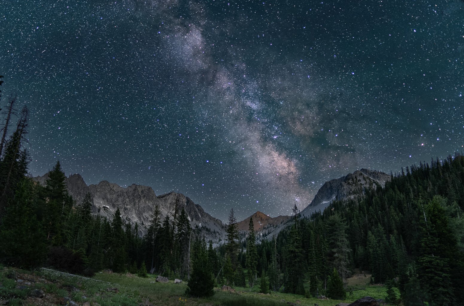
At the Deer Creek campsite, the biggest campsite closest to the creek was occupied, but I chose a small site with a view of the meadows in front of the mountains, to set up for some night sky photography. After hanging my food and setting up my tent, I set up my tripod and camera for some blue hour shots and experimentation for Milky Way photography. Later in the evening, I met the friendly backpackers next to me as they returned to their campsite - a mother and daughter with a dog. There are more large campsites further north on the Deer Creek trail, and these were all unoccupied.

The Milky Way over Siligo Peak, photographed from my campsite.
Day 3: Day hike to Four Lakes Loop from Deer Creek Camp: 8.7 mi / 14.0 km
This was a fantastic day hike, one of the best of a lifetime! The loop offered ever-changing scenery and terrain, with spectacular vistas from the ridgeline, serene mountain lakes that had few or no people, and plenty of opportunities for a refreshing dip or water refill. I had a short swim in cold Luella Lake before heading back to camp at Deer Creek. I was disappointed that the day was over. Although I saw a few other hikers throughout the day, only Diamond Lake was occupied by two campers as I passed through.


From the dry ridges to the lush valleys, the wildflowers were impressive.
Day 4: Deer Creek Camp to Granite Lake: 5 mi / 8 km Rather than hike 11 miles out to the trailhead, I decided to stop at Granite Lake, described as a premier weekend destination. This also allowed a short morning hike out before the long drive back to the Bay Area.


The wildflowers along the trail were as magical as they had been all week.
The trail up to the pass at Seven Up peak had many switchbacks and so was not too difficult in the cool early morning. At the top I met a nice man who lived only a few miles away from me in the Bay area! He was waiting for his son, who had jogged back to Granite Lake after forgetting an item, and was jogging back up the pass. The energy of youth! I relaxed at the top and enjoyed the views before heading down to Granite Lake.


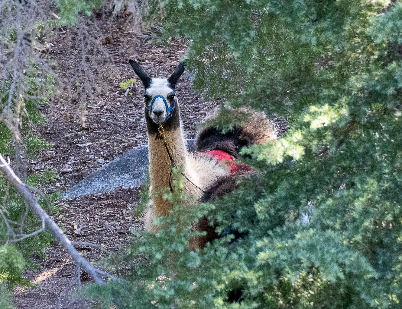
As I neared Granite Lake, the trail crossed a creek. As I hesitated and scouted the best location, I felt a hot breath on my arm and jumped! Right behind me was the quizzical face of a very cute llama, patiently waiting for me to cross the creek! The llamas were accompanied by a father and son, who showed me the best place to cross and even shouldered my backpack for me, before helping me across. Thus I met the family of Happy Homestead Llamas, who were out for the week, training their younger llamas for trail packing. They pointed me toward the best location at Granite Lake, and I hopped over the boulders and around the corner to a beautiful private location on a hill above the corner of the lake.


Near my campsite, I enjoyed more carpets of wildflowers, and climbed a small hill for a view of Mount Shasta.
Day 5: Granite Lake to Swift Creek Trailhead: 5.7 mi / 9.2 km

Granite Lake was beautiful in the cool morning light, and I snapped a few photos while packing up.

I couldn't resist a few more photos of the charming Happy Homesteaders, and I offered to take a photo of them in the meadow with their llamas for their website. I was quite impressed with the practicality of these animals! Their hooves do not tear up the trails as horse's hooves do. I even watched one daintily back up and defecate off the trail, rather than just scattering as they walk. Just like little eaglets, always defecating outside the nest! As I hiked along behind them, I started daydreaming about weeks-long expeditions in the wilderness with a friendly llama. The Happy Homestead Llamas rents and sells llamas, and offers them for day hikes as well.


Since I had my tripod, I stopped to take a few long-exposure photos of the creeks on my way out. I was sorry for this delightful trip to end. Although I usually don't repeat backpacking trips, I might make an exception for this route!
This was a fantastic route that I highly recommend. The wildflowers were just spectacular in late June, and the weather was perfect. Doing a loop from Swift Creek and returning via Granite Lake offers varied terrain and geography to visit. Backpackers can enjoy more isolation by coming in via Bear Basin trail, where I saw no hikers or campers, versus Granite Lake, which is reportedly quite busy on the weekends. The Four Lakes Loop is hard to beat for views per mile!
LOGISTICS
Photos by Cris Lewis Sony alpha 6600, Sony 18-135 lens, Sigma 16 mm f1.4 lens
Wilderness permits are available on a walk-up basis from the Weaverville Ranger station. Even if the station is closed, permits are available from the outside kiosk, and are free. No quotas exist, at least as of July 2022.
An excellent guidebook for the Trinity Alps Wilderness is Lewon, Dennis (2001). Hiking California's Trinity Alps Wilderness Falcon Guide, Morris Publishing. ISBN978-56044-713-9
Deer Lake is quite small and fragile, with only one apparent campsite on a ledge above the lake. However, Summit Lake appeared to be the best, although I did not descend all the way down to the lake. As a larger lake with more trees, it offers more privacy and options for camping, as well as being less fragile. Diamond Lake offers one stellar established campsite near the lake, which will be prime real estate and quickly occupied. Other campsites further from Diamond lake may be available, but these are a bit more exposed and thus less private. Luella lake was unoccupied when I visited, and there are apparently some established campsites above the lake. I found that camping at the Deer Creek campsite, and completing the loop as a day hike, made for a perfect day.
Feel free to download and share this GPX file of campsites and waypoints for this trip.