ABEL TASMAN NATIONAL PARK

On my first trip to New Zealand I went to the trouble of bringing along my folding Feathercraft Heron kayak, so I could paddle solo in some iconic locations on the South Island such as the Abel Tasman Coast. During my paddling trips in Canada and Alaska, I had sometimes wondered what it would be like to visit tropical warm waters and paddle in a bikini, with no need for bear cans or wet- or drysuits. THIS WAS IT- what a difference! Paddling the Abel Tasman coast offers a very relaxed itinerary, designed for leisurely distances, and time for extra hikes, beach lounging and nature watching. Truly a tropical paradise and a relaxing kayaking vacation very different from any others I had experienced!
Route Overview: Five Days, 75.6 km / 46 mi


LEFT: Location of the Abel Trasman Coast on the South Island. RIGHT: Paddling and hiking GPS track (in bold red) along the Abel Tasman Coast and within the Tonga Island Marine Reserve. Some of the designated campsites managed by the New Zealand Department of Conservation (DOC) are shared with the Abel Tasman backpacking Great Walk, while some are boat-in only.
While researching the Tasman Coastal paddling trip from home, I was unsure of a launch location, realizing I'd have to figure it out when I arrived. Fortunately, the friendly folks at the Barn Backpackers Hostel and Campground suggested that the closest place was a shallow tidal inlet of the Marahau River near the large DOC parking lot in Marahau, and just a few kilometers from the Barn Campground. I stayed at the Barn for two days prior to the trip, arriving in the late afternoon and spending the next day assembling the kayak and preparing gear. Assembly of the 17.5 ft. long Heron can be a chore, but the task was straightforward this time, if not a bit tiring in the hot sun. A local Kiwi commented on my having "quite a cool gadget there" as he watched it emerge from 2 bags. Afterward, I explored the launch site and calculated tides, and then checked in with a local water taxi service to ensure I had their contact info.


Day 1 -- Marahau Tidal Inlet to Torrent Bay: 10.8 km / 6 mi The next day I was excited to be finally paddling again, and eager to experience paddling in warm water and tropical seas. I was able to unload the kayak in the DOC parking area next to the tidal inlet, load up quickly, and button up and park the camper van in the DOC parking lot. There was just enough water for me to wade out the inlet to the open sea and launch. The incorrect assembly of a rudder pedal hampered my progress in the west wind, until I landed on a beach and executed a repair. How nice to be paddling in a bikini, shorts and a paddling jacket, and be able to splash around on the beach!

Marahau River Inlet to Torrent Bay. Hiking trails, including the Abel Tasman Great walk, are shown in red dotted lines.

Loaded up and ready for adventure!
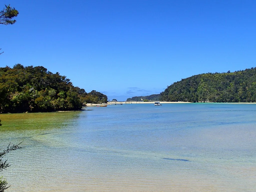
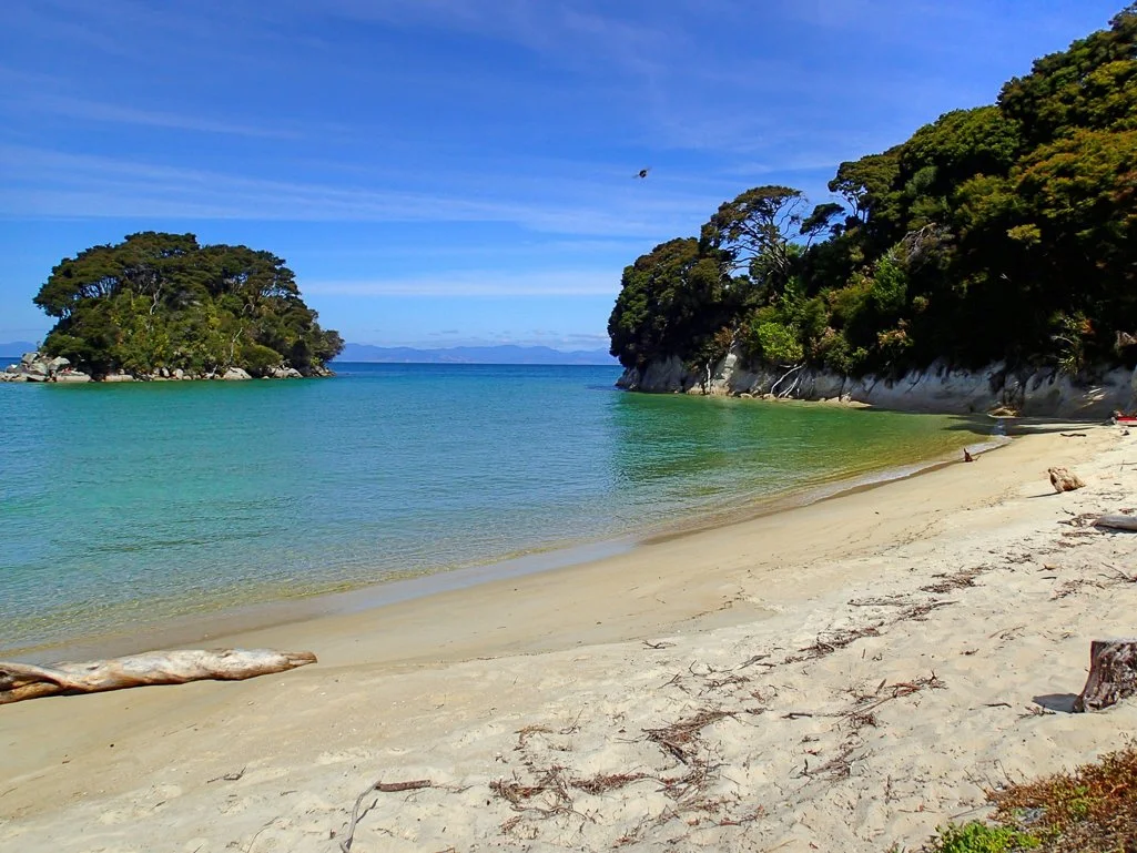
The distance to Torrent Bay was shorter than I had expected, and I realized my original calculations had been for paddling from Marahau Beach, a bit further south than the river. I had chosen the Torrent Bay campsite so that I could hike to Cleopatra's Pool, a famous landmark along the coast. The weather was perfect and the water a beautiful blue. There were quite a few kayakers and beachgoers paddling and enjoying the summer.


It was a bit of a hike with gear from the beachfront at Torrent Bay to the campsites, which were situated inside a bay. Although I could have paddled around, I suspected the bay was quite shallow from the charts, and decided it would be easier to leave my kayak tied up near the beach. The short walk felt good, and I had my tent set up in a cozy shady spot in short order. The campsites were separated a bit for privacy, with two long-drop loos across the trail, and water that required purification.
After unloading, I set off for the short hike to Cleopatra's pool, described as a worthwhile side trip for visitors to Torrent Bay. The ~ 8 km round-trip hike around the bay and into the woods was easy and quite pleasant.


When I first arrived at the pool area, it was filled with dozens of school children having a great time. I relaxed a bit and they departed en masse, led by incredibly patient adults who got them safely on their way and back to a neighboring beach. As I walked back around to the campsite, I saw the ebbing tide left the little bay quite dry. I was glad I had not paddled around to the campsite!
Day 2 -- Torrent Bay to Onetahuti Bay: 13.7 km / 8 mi Knowing I would need to wait for a higher tide in Torrent Bay, I lazed in my tent and had a leisurely breakfast. This was a decision I later regretted. I didn't launch until around 11:00 a.m., and I could already feel a stiff breeze as I headed toward the mouth of Torrent Bay. As I rounded the point, the headwinds increased, but picked up dramatically as I paddled past Bark and Mosquito bay. The last printed forecast I had seen had called for winds up to 30 knots in the afternoon. The paddling was getting to be a slog and I could see whitecaps everywhere. Knowing the wind could increase beyond my ability to make good progress, I decided to turn into Tonga Bay to trade my planned campsite at Waiharakeke Bay for one at Onetahuti Bay.

Torrent Bay to Onetahuti Bay
The beach was quite crowded with sunbathers and swimmers when I landed. I met Stu, a very nice man leading an eco-tour group in a boat. He was a sea kayaker himself, and we traded kayaking stories and talked about the local wildlife. He mentioned that Tonga island used to have some penguins, before a leopard seal set up residence and decimated the population. Stu pointed out the camp host to me, who eventually confirmed that I could trade my campsite at Waiherekeke Beach for Onetahuti, and I set up camp in an area just in front of the forest. Many of the beachgoers departed in various tour boats and water taxis, and new kayaking groups launched and landed. I was a bit dehydrated and tired, and relaxed for most of the afternoon on the beach after talking with a local guide of a sea kayaking group. The whitecaps and high winds outside the bay persisted until the evening and I was glad I hadn't tried to paddle further.


Onetahuti Beach, facing Tonga Island
Day 3 -- Onetahuti Bay to Mutton Cove: 18.5 km / 11 mi The next morning I was up early to ensure I could paddle before the winds picked up. The kayaking guide told me the forecast she got from her dispatch office was quite favorable, and I launched at ~ 8:40 a.m. It was another beautiful day and a spectacular paddle along the coast.

Onetahuti Bay to Separation Point and Mutton Cove
I was eager to get to Mutton Cove, so I didn't explore inside Awaroa Bay or Totaranui Bay as I paddled north. I could see that Totaranui Bay, which unlike most other campsites is accessible by vehicle, was quite busy with a lot of people, RVs, and a couple of anchored sailboats.
Slideshow of the Beautiful Coastline North of Onetahuti Bay


As I passed Abel Tasman Point, I saw and heard a disturbance in the water, and saw a big pod of 40-50 dolphins headed toward me. They were surfacing occasionally in high leaps, and slapping their tails. I took a short video, impressed by the size of the pod as they swam south in front of my bow. What a thrill!
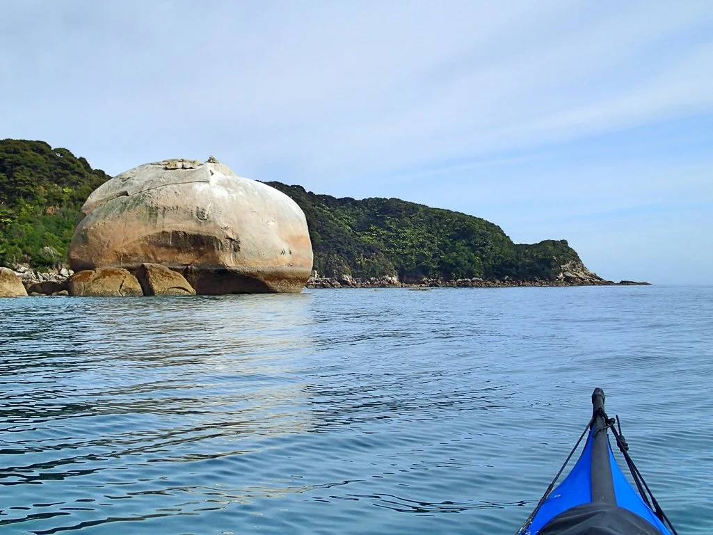
I paddled past Mutton Cove and out to Separation Point, where the water got quite a bit choppier. There was only one more DOC campsite on the Abel Tasman coast -- the Whariwharangi site just around the point. That site was accessible by vehicles and backpackers, and was quite a bit bigger, so I was happy with my decision to stay at Mutton Cove, which was accessible only by foot or boat. Before landing I explored the point and stayed a respectful distance from the fur seal colony, where several fur seals, including a few pups, were lounging on the rocks. These fur seals are not shy, and one came up quite close to my kayak as I drifted by.
New Zealand Fur Seals at Separation Point


A curious New Zealand Fur Seal through via telephoto (no, I wasn’t that close)
I landed at the delightful Mutton Cove in the early afternoon, and set up camp in a fairly empty campsite area. There was plenty of space above the sand, but no real privacy between sites as there was at Torrent Bay. After setting up my tent I lounged in the warm sun for a while, and napped peacefully. By mid afternoon there was a stronger on-shore breeze, but less than 15 knots.


The delightful beach at Mutton Cove
Day 4 -- Mutton Cove to Mosquito Bay: 16.8 km / 10 mi During the night I could hear the surf pounding on the beach, and when I woke there was a stronger, cool offshore wind causing a small, 1 meter high surf on the beach. I launched around 8 a.m., facing a minor headwind until I reached Reef Point, where the chop and headwind lessened.

Mutton Cove to Mosquito Bay
I paddled past Totaranui Bay and around the back of Tonga Island, and the water got gradually calmer as I paddled further south.


Paddling in to Mosquito Cove, one of the few campsites on the Abel Tasman Coast that is accessible only by boat.
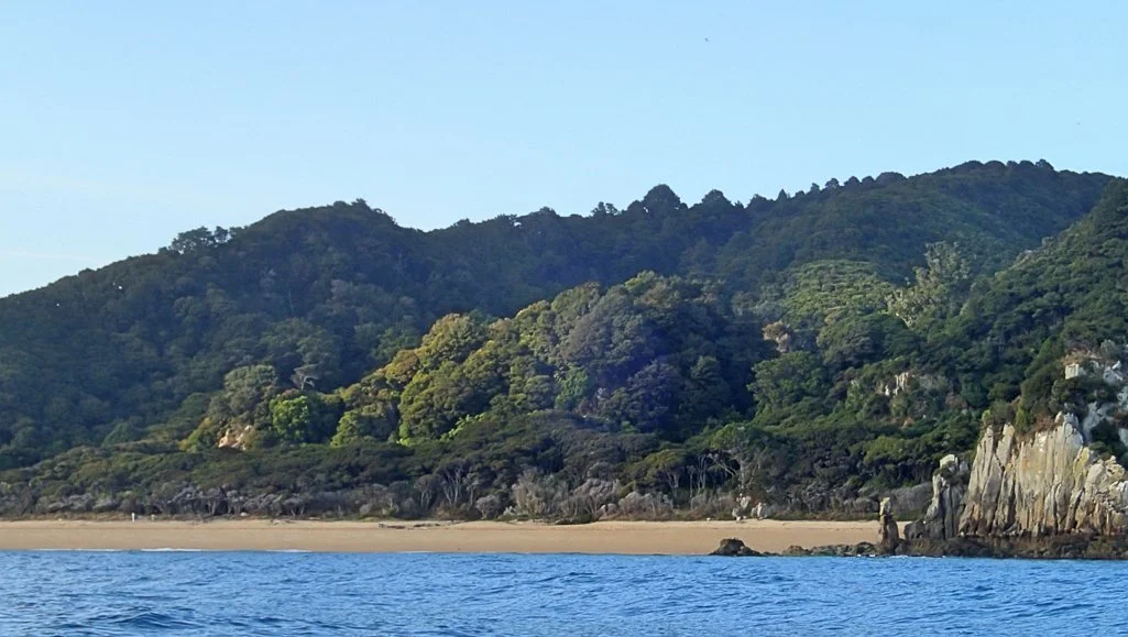
Mosquito Cove, where I landed before noon, offered another delightful campsite, with golden sand beaches, running water, and plenty of space for tents above the sand. I sunbathed on the beach after setting up camp, and watched some eagle rays in the shallow bay. There was a resident pair of black oystercatchers with a couple of young chicks they were guarding zealously.


I had finally figured out the New Zealand weather forecast system on my VHF radio. *Weather forecasts are broadcast on specific channels (for example, channel 67 for the Abel Tasman coast, and only at specific times. They are not re-broadcast, and so my efforts to get weather reports using my international Wx channel scans didn't work (see below). I was relieved to have solved the mystery, knowing I wanted to do more paddling in New Zealand! Plus, I learned that a cyclone (a new term for me!) was headed toward New Zealand, with stormy weather due the day after I expected to arrive back in Marahau. What luck! Winds for the next day were forecast for NE 15 knots, increasing to 25 knots at night. The day after that, winds were forecasted for up to 35 knots in some coastal areas, so I felt incredibly lucky about the timing of my trip.
Day 5 -- Mosquito Bay to Marahau Inlet: 15.8 km / 9.8 mi

Mosquito Bay to Adele Island and Marahau Inlet


I was up early the next day and was treated to a wonderful sunrise. So rare for me to see a sunrise over the sea! I had only a short time to take a few pictures before the light changed.
I saw that conditions were quite calm, so I didn't need to rush. In addition, I needed to time my arrival in Marahau to be within at least three hours of high tide, (not until 15:30) in order to be able to return up the Marahau River inlet. I took my time, and with the low tide, I had to drag and carry my kayak down the beach to load and launch. I set off before 9:00 a.m. and paddled south in a mild east headwind of 5-8 knots -- a beautiful morning.


I turned slightly southwest at Adolphe Point and headed toward Adele Island, which I had skipped on the way out. There were quite a few other kayakers and tour boats on the water, and I paddled leisurely to Adele Island to see the fur seal colony and the north side of the island. After watching their antics for a bit, I paddled around to a bay on the west side of the island for a leisurely lunch break on the beach, and a geocache hunt. While trying to take a macro photo of a large cricket, it jumped away and was promptly eaten by a nearby Herring gull. Oops!


After lounging on the beach, I reluctantly packed up to paddle back to Marahau. The east wind was picking up a bit, so that there were slight surf waves hitting the mouth of the river. There was just enough water to paddle into my original launch spot, although I had to backtrack to find the deepest channels. Although I was sad for the trip to end, I was happy to have had such great luck with the weather and the kayak, and had avoided the cyclone by one day -- what luck! I loaded up quickly given the rising tide, and a nice hot shower awaited me at the Barn Backpackers. The next day, the rain began and it continued throughout the area for several days. The Tasman coast was protected from the worst of the storm, but it was much worse in other areas.


This was a fabulous kayaking trip, my first in tropical conditions. Compared to my expeditions in western Canada and Alaska, this was truly glamping: paddling in a bikini, no bear cans, no drysuits, no mosquitos OR sandflies, and NO GRIZZLIES! What's more, the campsites were well tended, and many had running water and flushing toilets! The scenery was magnificent and the conditions very suitable and safe for solo travel. There are several opportunities for hiking, and just having a pattern of easy low-mileage days with extra time for sunbathing and nature-watching made for an enjoyable change of pace. How unusual is that: a very RELAXING kayaking vacation! I highly recommend this trip for anyone visiting New Zealand.
REFERENCES AND LOGISTICS
Photographs by Cris Lewis, Olympus TG-2
Information about the Abel Tasman Track can be found at the New Zealand Department of Conservation Website.
None of the kayak rental agencies will loan a kayak to a solo paddler, although they will loan very large doubles to 2 kayakers. This was the reason I went to the trouble of transporting my Feathercraft Heron, and I was very glad I did. I'll comment separately about the logistics of traveling with a Feathercraft.
The conditions along the Abel Tasman Coast were very favorable for kayakers. The guided trips offer very large and stable kayaks for their paddles, and the guides I met were very knowledgeable and friendly.
Unfortunately, there are no approved DOC campsites beyond Whariwharangi, so a longer expedition further north up the coast is not practical. Appropriately, New Zealanders frown on 'ninja camping' or 'freedom camping' on these beautiful beaches.
The Backpackers Barn offered limited secure parking for approximately $5 NZD per day. However, I learned that there was very little crime at the large DOC parking area, so I parked there for free. It was much closer to the launch, and I had no problems leaving my van there for the 5 days I was gone.
Marahau is a small town with few facilities and just a couple restaurants or small stores. Motueka is a bit larger, and everything is available in Richmond or Nelson, approximately 51 or 64 km south around Tasman Bay, respectively. The DOC site for checking in for the Abel Tasman Track is also in Nelson.
Weather forecasts are not broadcast on the typical Wx scanning station buttons available on most international VHF radios as in Canada and the U.S. Instead, they use channels specific for each area. Channel maps are available online; the Tasman Coast forecast channel was 67, and broadcasts occurred at 7:30, 13:30 and 17:30.