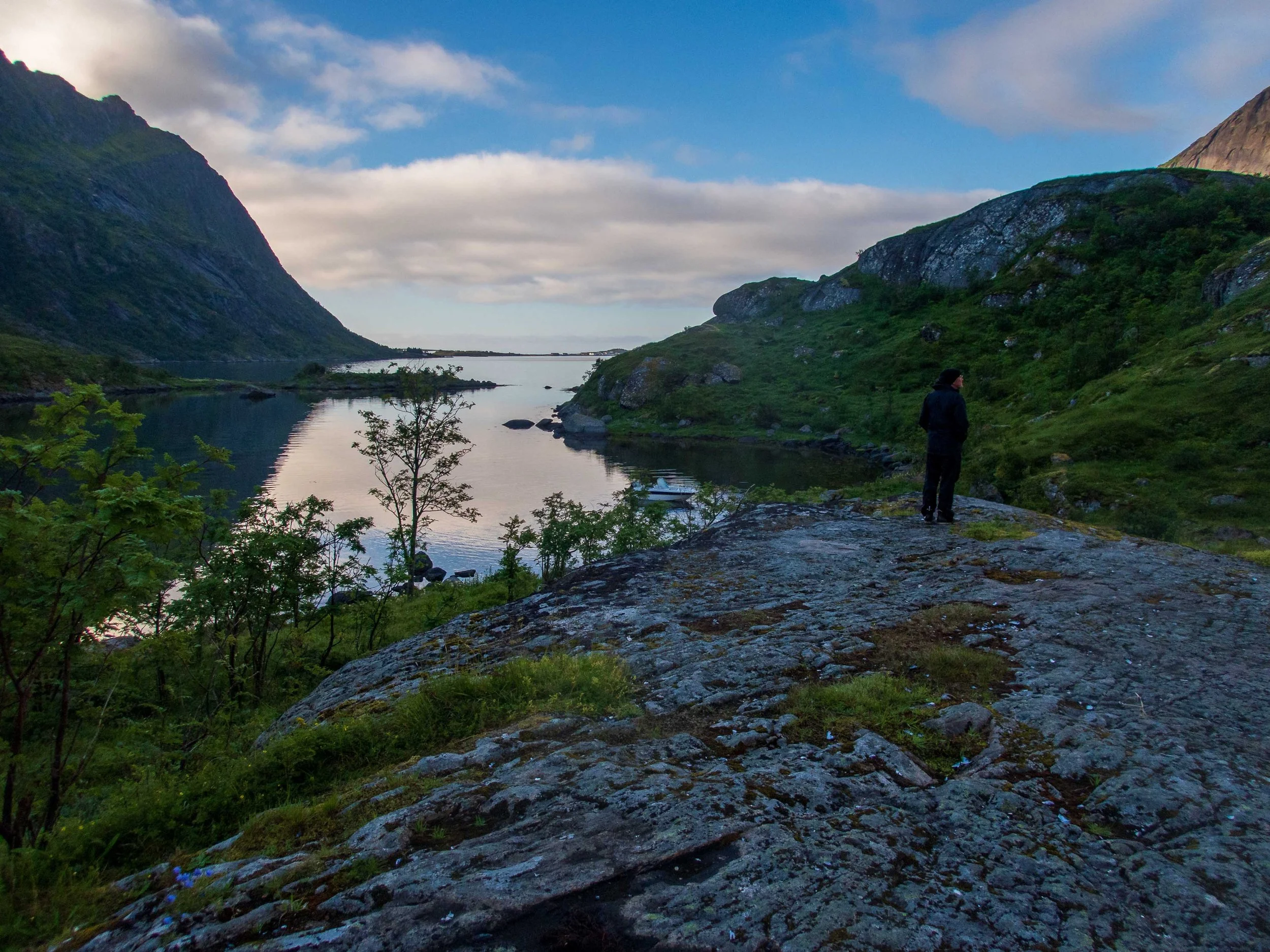
Lofoten Islands, Norway

After our 2023 sea kayaking trip in Iceland, Dick Lampman and I began comparing notes on a potential trip for the summer of 2024. Several people on our trip in Iceland had recommended sea kayaking in the Lofoten Islands of Norway, and I had made a brief sightseeing visit to Bergen Norway for a few days after visiting Iceland. I fell in love with Norway immediately, perhaps due to my Norwegian heritage. Dick and I settled on the Lofoten Islands quickly, and we recruited L5 certified paddler Kim Grandfield of Livermore, California to join us. After several months of careful planning, we had a plan to fly to Norway, rent kayaks from a known outfitter Lofoten Aktiv, and see how far we could paddle in the two weeks available to us. We knew the route was subject to high winds and potential surf, depending on location, so we planned to be flexible with our route, and we designed several bail-out options. We also researched the historical weather patterns, and packed our warm clothes for this paddle that was some 180 miles above the Arctic Circle.
Route Overview: 180 Nautical Miles*, 14 Paddling Days


Pre-Trip Logistics: Dick Lampman is a master trip planner! This was my first sea kayaking trip where I didn’t have to do all the planning, and I so appreciated Dick’s enthusiasm, thoroughness, and exquisite attention to detail. My first step in planning was to purchase the best guidebook for sea kayaking in the Lofoten Islands, “The Lofoten Islands, A Sea Kayak Guide to the Magical Isles” by Jann Engstad. Jann is an expert kayaker himself and owner of Lofoten Aktiv, a highly reputable company that rented us our kayaks and offered invaluable guidance before, during, and after our trip. After the three of us reviewed the book, we identified the locations we’d most like to see, the places we could afford to miss, the “crux moves” and potentially risky locations, and a potential circumnavigation route. Dick figured out all our flight and lodging options: we all flew to Oslo via Copenhagen, then to Bodǿ on the northwest coast. We stayed overnight in the charming town of Bodǿ, before catching a small plane the next morning to Svolvær, the largest town in the Lofoten Islands. Jann was kind enough to pick us up, with all our gear, at the Svolvær airport and give us a ride back to Kabelvåg, the location of his kayak shop and our first night’s lodging at Sandvika Campground.


Diagram of day paddles (denoted with “A”) and expedition paddles (“D” and “Y”) from Jann’s book. The risky areas are the Moskstraumen and the long narrow channel the Raftsundet, where the Trollfjorden is located. The red star is our starting location at Kabelvåg. We hoped to be able to get to the Nature Preserve on the northwest side, and circumavigate the islands if possible.

Cris & Dick ready for the flight to Bodǿ. Photo by Kim Grandfield
Dick and I rented the P&H Scorpio MV’s, the same model we had rented in Iceland. Kim needed an HV model to accomodate his tall frame. Dick and Kim did a test pack of their boats, but I didn’t bother, instead focusing on making sure the outfitting was in order and sorting gear. Although I had planned to sleep in my tent, there was rain in the forecast, and the guys were kind enough to let me sleep on the couch of their cozy cabin; this would save a bit of time on the morning of our launch.
We were all slowly trying to catch up to our jet lag, but were up in time to be packed up by 8:30 a.m., when we called Jann to pick up the gear he would store for us during our trip. After a few last questions, Jann kindly circled some of the best campsites on one of our charts, although quite a few campsites were described in his book. I had done my own scouting prior to the trip, creating a GPX file of all the campsites in the book, plus a few others that seemed possible based on scouting Google Earth and one of Norway’s travel camping websites. I copied over the circled campsites to our other charts, and we prepared to launch. It is always such a joy to finally paddle off in a loaded kayak after all the logistics of traveling!
Day 1: Kabelvåg to Eidisholmen Island - 17 nmi, 31 km.


We launched in light rain, and immediately felt the magic of the surroundings. There was little civilization just west of Kabelvåg, so we were already immersed in views of misty jagged mountains as we paddled in modest following seas.
It felt great to be on the water after all our travel, and we thoroughly enjoyed the awe-inspiring landscapes. We stopped for lunch at a small beach and saw what appeared to be the skeletal remains of an old wooden ship.

Photo by Kim Grandfield

We stopped at a campsite Jann mentioned at Sandviksodden, but Kim and Dick didn’t like the sulfur smell of the seaweed, nor the sheep droppings that were scattered plentifully around. (As the trip continued, we soon learned to just bat away the ubiquitous sheep poop and set up our camp.) So we continued south toward Stamsund, looking for another campsite Jann had mentioned in the book. We never found that campsite, but while stopping on land I met a nice Norwegian couple out on a walk, who suggested we paddle across to a small island where we were guaranteed a beautiful isolated campsite. After a long first day of paddling, we were happy to land. The location was indeed beautiful, with wildflowers blooming and with just enough flat spots for our three tents. When I awoke in the middle of the night, I was treated to a classic Norwegian “sunset” over the hills. As we were traveling in July, the sun never really set during our entire trip. I learned to sleep with my beanie rolled over my eyes to help me sleep in what amounted to broad daylight.
Day 2: Eidisholmen Island to Vassvikvatnet - 15 nmi, 27.8 km.

Although the sky was grey and overcast, there was no rain as we hauled our kayaks over a barnacled shore at low tide to launch. As we paddled southwest, we saw the little “rorbu” fishing huts that are famous on the Lofotens, as well as some fish farms. We also saw quite a few Eurasian Oystercatchers, (just as noisy as the Black Oystercatchers in the U.S.), some Pigeon Guillemots, and a few Cormorants. We stopped for lunch in a tiny, deep cove at Bårdsundtinden, and had no problems crossing the Nappstraumen with little wind. There were several vacation houses on Straumoya Island but a resident there directed us to a bay on the ‘mainland’ just to the west, at Vassvikvatnet in the Fisken area of Flåkstodǿya Island. This was a quiet, isolated campsite near a small stream.


Day 3: Vassvikvatnet to Vorfjorden - 12.2 nmi, 22.6 km.


We were slowly catching up on our sleep, and had an unhurried launch after breakfast. Of course the sheep were everywhere, so I treated all of our water reservoirs from the nearby stream with my electronic Potable Aqua device, a handy chlorine generator smaller than a cigarette pack that I take on my kayaking trips. One charge before the trip is enough to purify more than 180 liters of water. Unfortunately it is no longer sold.
Paddling conditions were perfect, with little wind and almost glassy water. We made good time proceeding almost due south down the coast and across Nusfjord inlet and Skjellfjorden, passing the island of Kunna. We stopped for lunch at a small, charming fishing village, complete with a house with a sod roof.


After passing the large inlet at Sund that opens up to the Selfjorden, which flows all the way to the north coast, we turned west and paddled under the first bridge at Hamnoya, where there was quite a bit more civilization. For the first time, (and only time on the entire trip), we saw other kayakers on the water, as part of a tour group that was exploring local waters. Jann had told us about a campsite inside Vorfjorden, and it was picturesque and unique indeed! We paddled all the way to the end of Vorfjorden, seeing only what looked like a rock wall at the end. Then, we saw a narrow entrance into the lagoon at Flovatnet, which had a wonderful campsite on its shores. We got our tents set up quickly on a bluff overlooking a mirror-like lake. At this point the weather was quite warm, and we were happy to get out of our drysuits, but then we got nailed by many hangry midges! They really did a number on me, getting in numerous bites on my neck that itched for almost the entire rest of the trip.


Day 4: Vorfjorden and round the Moskstraumen - 15.4 nmi, 28.5 km.

Day 4 Paddle from Vorfjorden to Buvågen (in gold)
Our tentative paddling plan for the day was to continue southwest toward the small town of Å (pronounched “Oh”), and then set up camp at Ånstad, to position ourselves for the crux move the next day of rounding the tip of the island at Lofotodden, entering the Moskstraumen at slack, and camping in the lagoon at Buvågen. We had spent a great deal of time reading and studying the Moskstraumen, one of the largest and more infamous ocean current and whirlpool formations in the world (see below). Fortunately, Jann’s book offers excellent guidance on the challenges of navigating this dangerous current, so we knew what times we’d need to round the point at Lofotodden to begin paddling north. We were delighted with the weather, the mild winds, and the progress we’d been making so far.
Our first stop was the picturesque town of Reine, and we paddled into the harbor to check out the beautiful wooden sailboats and the modern houses nestled below the snow-capped mountains. It was another hot, sunny day (> 70°F; 21°C.), certainly not the weather I was expecting for these waters some 180 miles above the Arctic Circle! (See below for my education on the difference in climate between Iceland and Norway.)
We got our first look at the Hurtigruten ferry, which has been connecting the Norwegian coastal towns since 1893.
Slideshow of Reine


After visiting Reine, we continued down the coast, paddling in glassy waters with a light breeze cooling us off a bit. Perhaps due to the mountainous terrain and the deep fjords, the sea water is incredibly clear with great visibility from the kayak. We saw numerous jellyfish throughout our trip, including the little box jellies with ‘fluorescent’ pulses as they moved.
After about 8 nautical miles, we paddled in to the little village of Å, the last stop on the highway that connects the Lofoten Islands. From here, no more roads or civilization until we reached towns many miles away on the northwest side of the islands. Fortunately, the forecast for the next few days was favorable. We made the most of our stop in Å, with Dick and Kim treating themselves to a tasty burger and fries at a local cafe; they were quite friendly and tolerant of our drysuit paddling attire. We also stopped at the renowned cinnamon bakery, which uses a stone oven built in 1878. (Kim thought the buns might be a bit over-rated, and over-priced.)


Next stop: Preparing for the Moskstraumen!
The Moskstraumen
The Moskstraumen is a large stretch of the sea filled with fast currents, tidal eddies, and whirlpools, found at the southwestern tip of the Lofoten Islands. Deep underwater currents, traveling as fast as 6-12 m/h (11-20 km/hr), well up in this area, and mix with the tidal currents streaming between the Atlantic Ocean and Vestfjorden. The unique bathymetry between Lofotodden at the tip of Moskenesøya Island and Vaeroy Island, approximately 10 mi or 16 km southwest, creates eddies and whirlpools large enough to be visible from a plane or on satellite images. Stongest in July and August, the surface currents can be up to 5 miles (8 km) wide, while the whirlpools can be up to 150 feet (45 meters) wide and cause ripples up to a meter high. The Moskstraumen represents one of the largest open ocean systems of tidal eddies and whirlpools in the world.(1)

Needless to say, the Moskstraumen has had its place in history: It was described in 13th century Norse poems and appeared in the 1539 Carta Marina oceanic map. Historical accounts and images, no doubt exaggerated, were complemented by writers such as Edgar Allen Poe, whose use of the term “Maelstrom” in his 1841 short story “A Descent into the Maelstrom” is believed to be the first use of this word in the English language. It was also made famous in the climactic scene of Jules Verne’s novel, “20,000 Leagues under the Sea.”(1)
From Å, we paddled south to Ånstad, an abandoned fishing village where we planned to camp, stock up on water, and launch the next afternoon so we could round the corner at Lofotodden at slack tide. Fortunately, Jann’s book provided an excellent and helpful diagram for what to expect from the Moskstraumen at different tides. As we pulled into the ancient stone landing structures at Ånstad, we saw that a small recreational motorboat was tied up, and two different families were occupying the area nearby the shore. We nevertheless clambered ashore in the heat, secured our kayaks, and began exploring for a water and camping site. As it turned out, we had to hike up and over a steep hill to access water at a lake, as there was no creek outflow. Also, it seemed the most favorable campsites were taken by the two families, and we certainly didn’t want to crowd them. As we struggled up and down the hill with our heavy water bladders, Dick had a genius idea: Rather than stay at Ånstad in the sweltering heat for another day, why not leave to round the point into Buvågen cove right now? The timing was late afternoon, and actually perfect to cover the distance to the point so that we could round the corner near slack. GENIUS! The guys were plenty full from their big lunch, and we all welcomed the idea of continuing on.

Diagram from Jann’s guidebook on expected currents at different tides. Super helpful!
I quickly treated our lake water and we jumped into our kayaks. Given the calm conditions, the paddle south was a delight, and we rounded the corner and headed in to the area of the Moskstraumen near slack. While we could see mild waves south of us, and a few fishing boats drifting in offshore current, the paddle around the point was uneventful, with only mild clapotis and no significant swell. Thanks to benign conditions and planning, the paddling into the Moskstraumen was a non-event! We paddled into the cove at Buvågen at 7:30 in the evening, with plenty of daylight left. We had the entire bay to ourselves, and this campsite was my favorite of the entire trip! I would have loved to stay an extra day and hike and explore, but we felt we needed to make the most of the benign conditions.


Day 5: Buvågen to Horseid Beach on the Northwest Coast: 14.7 nmi / 27.2 km
The day dawned cool and cloudy, and we were happy to have escaped the midges. The timing of the ebb for our launch was ideal: by launching just before 9:15 a.m. we were well positioned to catch a small ebb out of the harbor and around the corner of Kjellsneset to start pointing north. We were still exhilarated from passing successfully through the Moskstraumen, and I was loving the feel of the open ocean, with its higher swell and fresh, stronger breezes.
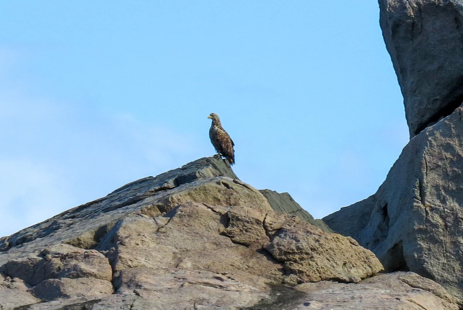
We passed by dramatic cliff faces and saw more seabirds, including cormorants, pigeon guillemots, and our first sea eagle. Although there were interesting places to explore on this southwestern coast of the Lofotens, including some ancient land caves, we decided to make the most of our fair weather and paddle to the next beach that was protected from large swell at Horseid. In the future, I’d love to come back and spend more days on this part of the coast.

We paddled north past Revsvika and after about 10 nmi we looked for a place to land for lunch, near Hermansdalen. There was a small rorbu further inshore, but Kim found a small reef that we were able to land on for our break.
At some point, as we paddled north up the coast, we noticed we did not seem to be going very fast, in spite of a relatively low wind at less than 15 knots. I started checking speed on the GPS, and sure enough, we were crawling at only 2 to 2.5 nmi/ hr. We realized we must be in a current, which is more difficult to sense in the open ocean than in a smaller body of water. We were a bit puzzled, as we thought the predominant ocean current would be the “Norwegian Current”, the residual of the Gulf Stream current near the eastern United States. These unexpected opposing currents were similar to those we experienced on one day of our kayaking trip in Iceland, and thus we continued “getting schooled” in ocean currents!

Day 5 Track: Buvågen to Horseid Beach (in gold).

Ocean Currents in in the North Atlantic

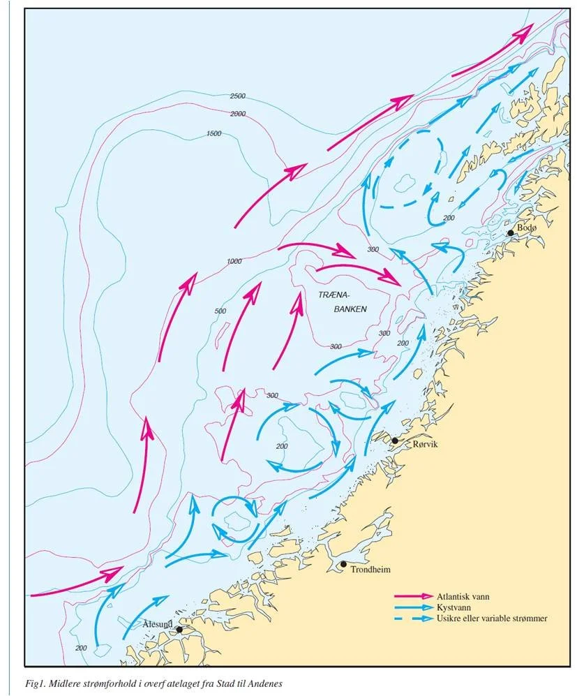
Later that evening in camp, Dick showed us a couple pages he had copied from the Norwegian Coastal Pilot (ever the perfect planner is Dick). It showed that the predominant current on the northwest Lofotens might expected to be from the SSW, but that we could certainly expect confused circulating currents along the coast, labeled as “uncertain or variable currents” on the chart), assuming these were replicated on a smaller scale. That, plus the occasional headlands meant we indeed faced opposing (NE) currents occasionally. From then on, we were more careful about feeling opposing current, checking our speed, and occasionally zig-zagging further or closer to the coast to find eddies. But that day, it meant we arrived in Horseid Beach a bit more tired than usual after 15 nautical miles. We faced quite a bit of turbulence and clapotis around the point at Horseidmulen before pulling in to the beautiful broad, sandy beach at Horseidvika. What a fantastic beach and fabulous campsite!
After finally getting all our gear up the hill that overlooked the beach, setting up camp, and preparing dinner, we were all pretty tired. But we slept well, even in the bright daylight at 11 p.m!


Day 6: Horseid Beach to Flakstadoy : 9.1 nmi / 16.8 km
The morning sun was just coming over the mountains behind us as we launched from the beach and paddled out. Conditions were great, as we were in wind shadows of the headlands in front of us for most of the day. Although we had considered stopping at Kalvika beach and exploring the caves there, we were making such good time that it seemed a bit too early to stop. Instead, we continued paddling, enjoying the warm weather and gentle breeze. We faced much bigger swells and headwinds as we paddled around the exposed point at Bergsneset, but it was actually easier than the point at Horseidvika the previous day. We had planned to camp at Mulstoa for a shorter day, and we arrived there in the early afternoon to have some lunch and check out the site. We saw that someone was staying at a private rorbu there, but we couldn’t seem to find them to inquire about permission to camp. In addition, there was no water to be found, perhaps due to the dry conditions. So we decided to round the corner and paddle a bit further to the beach camp at Flakstadoy.


Flakstadoy offered a nice beach where we could camp and stash our kayaks. We were now back in the territory with roads and civilization, all too soon. But just about a km away was a public RV campground, where we could pay for access to showers, bathrooms and fresh water. The weather remained perfect, although quite warm. We were always happy to take off our drysuits in the warm sun.
Day 7: Flakstadoy to Utakleiv: 15.5 nmi / 28.7 km

The morning air was cool, with minimal wind as we paddled northeast, crossing the bay. In our planning session the previous night (Dick called these meetings our “chart séance”), we had decided to cross the bay directly and stop at Vikten. We thus bypassed our first large town on the north side of Ramberg. But we were not in need of supplies, and it would have added unnecessary miles to our journey. There were a few folks out enjoying the clear day at Vikten, and it felt good to stretch our legs on the beach. Kim and I walked over to a coffeehouse, where I got a couple delicious slices of fresh banana bread, and we brought back a bottle of coca cola for Dick (his favorite). It was a relaxing stop, and we were in no hurry.

From Vikten we paddled north to round the point at Hornneset, which allowed an escape from fairly minor headwinds. We then followed the coast along Myrland, spotting several campsites along the way, until we reached Storsandnes, the suggested crossing point for the Nappstraumen. The Nappstraumen is one of the largest flow of currents in the Lofoten Islands, traversing all the way from North to South. Fortunately, Jann’s guidebook once again had good recommendations for the best time and location to cross. Although we were not quite at slack, we found the crossing to be a non-event, requiring only a slight course correction. Once across the Nappstraumen, we paddled into the ~ 1.5 nm deep bay, headed for the beach at Vik. As we approached, we could see only a few buildings, far away. However, as we neared the beach, we were astounded to see hundreds of scantily clad Norwegians at the beach, with a long line of camper vans and tents spread out along the entire bay! Kim dubbed it “The Norwegian Riviera”. We landed to evaluate our options, somewhat dismayed at the crowds and the challenge of being able to camp there, as there were few free tent sites and our kayaks would have been stored far from our tents.


I checked my chart and saw there was another beach at Utakliev, one bay to the northeast. Kim, meanwhile, called Jann, expressing his dismay at all the crowds and minimal tent sites. Jann said, “What do you expect, it’s the warmest summer day in the Lofotens, everyone wants to go to the beach!” He, too, suggested Utakliev, so we headed back out the long bay, and around the corner to Utakliev. This beach had less accessible roads and was less crowded, although a few more tents joined us before the day was over. The campsite was quite civilized with a grassy beachfront lawn for camping and facilities at the far west edge. Of course, as always, sheep, and sheep poop, abounded. We became adept at flicking the dried dung with our paddles or trowels further away from our tent sites. It was quite warm, and I slept on top of my sleeping bag with minimal clothing to stay cool.

When I awoke in the middle of the night, I was treated to a nice “sunset.” It was actually a bit darker than it appears in the picture.
Day 8: Utakleiv to Borgvaer: 12.3 nmi / 22.8 km
This proved to be a great day of paddling! We had a leisurely launch around 9:40 a.m. and paddled due north, staying just inside the bay to avoid mild N winds and currents. After rounding the point at the north end of the bay, the seas became more choppy and confused for several kilometers. The water became more calm as we rounded the next point at Kleivneset, and a cool fog started drifting in from the east. The fog increased along the coastline from Kleivneset to Eggum, and there were quite a few boulders and reefs in the water, giving us a delightful opportunity for reading the water and rock gardening. There was a long hiking trail along the shore southwest of Eggum, but few places to land due to the rocks and boulders. We finally stopped for a quick bio-break in a very shallow bay, but we didn’t stay long as the tide was ebbing and we would have faced a slog of pulling our boats back to deeper water. Continuing on, we stopped at a sandy beach near the lighthouse at Eggum for a more relaxing lunch. We spoke to a very nice woman who was enjoying the beach with her family, and she told us of her history on the Lofotens.


We launched for our campsite at Borgvaer around 3, and noodled our way through a broad archipelago of tiny islets and somewhat larger islands. The flat landscape and many broad islands made me grateful that I had loaded marine-style charts on my GPS, as it made it easier to know which bays were dead ends and which offered a passage way around the islands to our campsite on the east side. Kim used the Navionics chart he had downloaded to his cell phone, and with the falling tide we had to push or portage our way through a couple passages to find our way. We finally arrived at the waypoint I had marked for Borgvaer, and it was indeed a delightful campsite—my second favorite of the entire trip! It was completely uninhabited, and had a flat, spacious grassy area for tents, and plenty of space to climb up into the hills above the tents to explore and take pictures. Kim discovered some wild cloudberries, our first introduction to these rare and delicious berries that are prized for their subtle taste. They are generally not cultivated; indeed, we noticed on our return travels that a jar of cloudberry jam sold for more than $20 USD for a 14 oz jar!
The sheep inhabiting the island seemed rather put out by our presence; they stood on a hillside in the fog, staring at us. But they didn’t miss the opportunity to leave a deposit right next to my tent when I stepped away to explore.


Day 9: Borgvaer to Sunnlandsfjorden : 13.6 nmi / 25.2 km


We launched in mild grey fog in calm, cooler weather. Having slept poorly, I was more tired than usual. Kim wanted practice navigating with his Navionics on his phone, so he took the lead as we wound our way through the low-lying islets until we reached the more open sea. There, we experienced a delightful and mild following sea, giving us a gentle push east. Unfortunately, the loading of my boat must have been uneven, and I began a 3-hour wrestling match with the kayak as I experienced weather-cocking. Dick was kind enough to loan me his 3-liter water bag, which helped. Note to self, you need more weight in the stern when you don’t weigh that much yourself! We landed at Hovsvika beach for lunch, a bit sweaty from the absence of cooling wind, even though there was minimal sun. From Hov, we paddled the ~ 4 nmi crossing to Brenna, where we proceeded around the corner in search of a campsite. At the location Jann had provided, some folks from Norway’s Green Party were celebrating, so they directed us to another small cove to camp. Fortunately we got permission from the owner to camp amongst his sheep just above the high tide line. It was an isolated area with only small summer cabins on a dirt road.

The small cove with tiny shore near a dirt road where we met Tobias Kurz.
It’s a small world! As we were setting up camp in a small space with our kayaks almost next to our tents to ensure they were above the high tide line, a friendly fellow walked up to us from the dirt road saying hello. His name was Tobias, and he was a fellow kayaker from Germany. He was staying at a friend’s house just up the road and was out for a walk to stretch his legs. He told us he saw our tents and kayaks and thought to himself ‘Hey, those are real expedition kayakers, I have to talk to them!’ He was on an extended kayaking journey himself, paddling solo from the west coast of mainland Norway. We compared notes on locations and as he was traveling in the opposite direction to us. When we told him we were all from the San Francisco Bay area, he said, “Oh, I met a woman from the Bay area recently who was paddling with a group here initially. But the group didn’t want to go as far as she did, so she paddled by herself. She wasn’t afraid of anything!” When he told us the woman was German like himself, I said, “Oh, you must be talking about Katrin Tomanek!” Sure enough, we were both referring to Katrin, an awesome endurance sea kayaker who has completed several long-distance expeditions, including combination bike and kayak trips. Having not seen any fellow kayakers the entire trip (except a small tour group in a bay), we marvelled at the slim chances that would allow us to meet on this small stretch of land, and both know a paddler living over 5000 miles away. Tobias and Kim shared Facebook notes, and later Tobias shared the track of his impressive trip. He, too, was making the most of the fantastic weather to put in as much distance as he could. An impressive journey with some high-mileage days!


Day 10: Sunnlandsfjorden to Kråkoya Island: 12.7 nmi / 23.5 km
Once again we launched around 9:30 a.m. in a cool grey fog to proceed north through some islands toward the island of Haugoya, where we had contemplated camping the previous night. Part of this area was a protected bird sanctuary.

Blåbrygga = “Blue Bridge” in Laukvik harbor

There was almost no wind, and the day was growing warm. We stopped briefly at Laukvik, where we explored the harbor a bit, thinking we might get extra water or a coffee for Kim, but nothing appeared to be open or easily accessible from the water. As we continued east, we were losing the feeling of the open ocean as the northern islands of Vesterålen began to appear. We crossed the bay at Delp, where Jann’s book had warned of potential surf, but there was absolutely no surf whatsoever. We stopped on the beautiful beach at Korsodden, which we had all to ourselves as we enjoyed lunch.


We occasionally saw these large stone cairns, which may have marked a trail or passageway to the mountains. The beautiful jellies were plentiful in the calm waters.
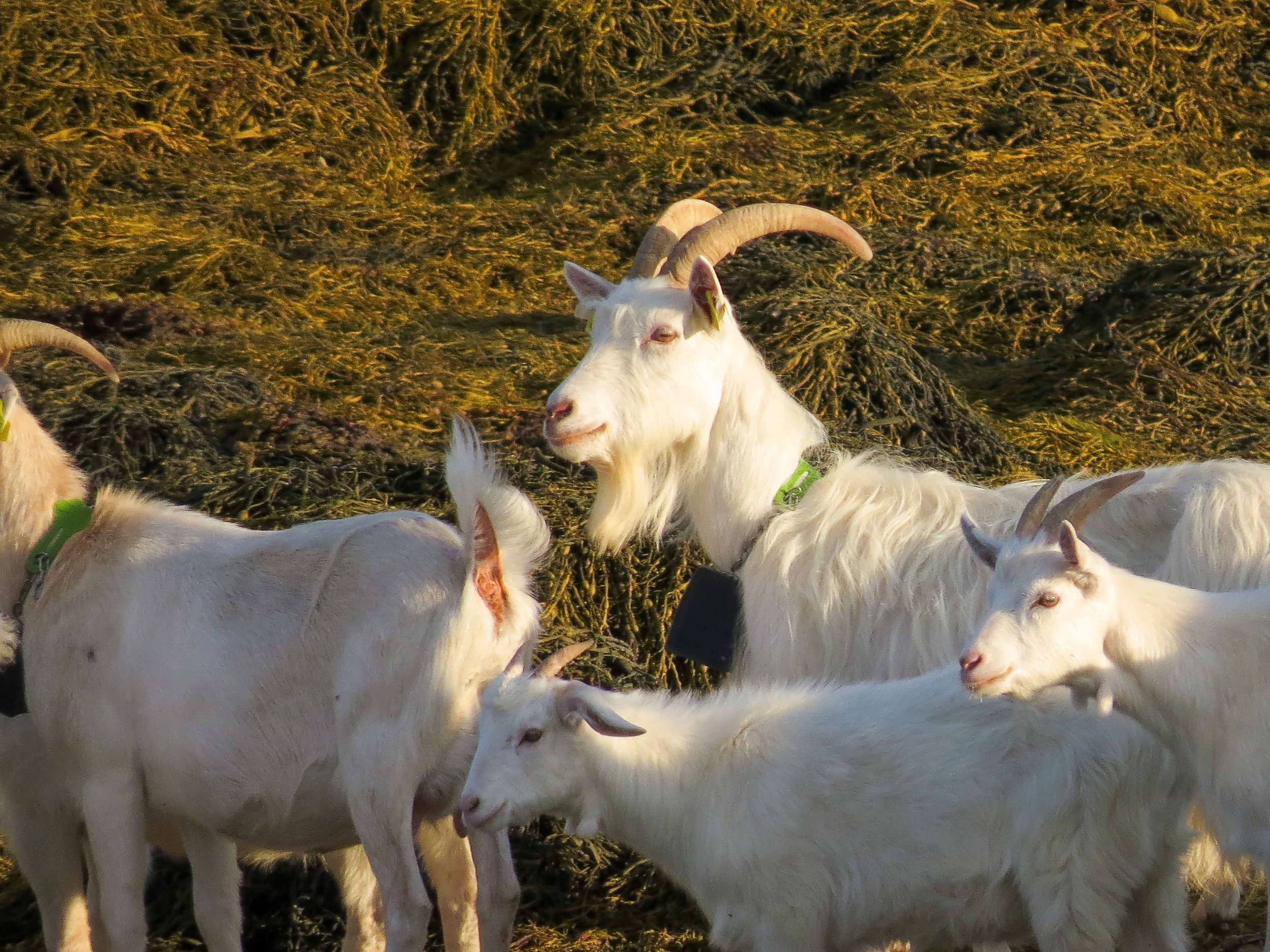
After another crossing of the bay to Korsneset, we came to the island of Kråkoya, where we set up camp. This was another peaceful island great for camping, except that it dried out a bit at low tide, requiring a bit of navigation to escape. Surprisingly, there were no sheep on this island, but there was a large herd of domesticated goats. As soon as the tide lowered, Billy led his herd across the flats to another part of the island, apparently not wanting to share our space.

Day 11: Kråkoya Island to Brottøya Island: 9.9 nmi / 18.3 km
With the trip nearing its conclusion, we kept closer tabs on the weather. So far, we’d had no rain, and the forecast continued to be quite favorable, showing possibly rain in Svolvær on the potential last day of our trip. But this day was already quite hot in the morning, and I debated wearing my drysuit fully or partially. I ended up suiting up, as I saw a breeze on the water, but Dick had his rolled halfway down. After navigating our way out of the island at low tide, we proceeded east at a slower than usual pace, hindered by a slight flood and mild winds.
After lunch on Slåttoya Island, we made our way to Brottøya Island, where there was a beautiful site inside a cove. There was an unoccupied rorbu there, so Kim called Jann to check if it was okay to camp below the charming little cabin. Jann assured us it was, and this became my third favorite campsite of the trip. We were so relieved to land and get out of our hot drysuits—we wore as little clothing as possible while setting up our tents and relaxing a bit before dinner. I continued to be surprised at the hot, dry weather!
Below I offer a comparison of historical weather versus our experienced weather—talk about climate change! Instead of max temperatures of ~56°F, we had max temps of > 80°F, and averages from 60 to 70° F. Winds were also much lighter than the average 15-30 mph. All the locals said the weather we were experiencing was highly unusual; but lucky for us!
Right: The cabin on Brottøya Island


Brottøya Island, my Third-favorite Campsite of the Trip


Historical Temperatures, Wind Speed, and Wind Direction in Lofoten from Meteoblue Weather


Actual Weather Conditions in Bodø in July 2024
Unusual weather made for favorable, if warm, paddling conditions. Next time I’ll pack at least one piece of lightweight clothing.

Actual weather in Bodø, Norway in July, 2024. Temp in Farenheit, Precipitation in inches, Wind speed in mph
Day 12: Brottøya Island to Trollfjorden and Brakøya: 12 nmi / 22.2 km
In our chart séance the previous night we briefly reviewed the tide diagram, suggesting the tide would be south-flowing around 11:30 a.m. Fortunately, there was a small south breeze that cooled things off a bit; it was still quite warm during the night. We launched around 10:15 a.m. and paddled east then south to enter the Raftsundet. This large, north-south facing channel flows all the way from north of the Lofotens to the south, and its narrowness means it is subject to significant currents of up to 4 knots. We had a leisurely launch at 10:15 a.m., and we noticed we had a small flood against us as we entered the channel at Hanoya Harbor. This should have triggered alarm bells, but I was too busy enjoying the sights. We wanted to collect water at a designated creeksite along the way, but it appeared to be dry. Kim spotted a dock and paddled ahead, and was lucky enough to meet a kindly couple preparing to head out in their motorboat for a day on the water. When Kim inquired about a place to get water, they insisted on halting their trip and helping us. With Kim’s help, they gathered all our water bladders in a wheelbarrow and filled them for us; enough to last the rest of the trip! They were incredibly friendly and kind, and mentioned that their daughter was living in Monterey Bay, California, just a few hours south of us! Another reminder of our small world. After thanking these kind Norwegians, we proceeded south toward the narrowest part of the Raftsundet.


Just before the pinch point, Kim spied a nice beach on the west side and suggested stopping for lunch. As we crossed the channel, I noticed an opposing current that changed my ferry angle, setting off an alarm bell that I actually paid attention to this time. I asked the guys if they noticed it, and Dick too, remarked on the change in landmark visibility for his ferry angle. As we set about having our lunch, we watched the boat traffic on the Raftsundet. Soon, we heard a new noise, and noticed riffles out in the center channel that were growing larger. A small Zodiac tour boat gunned south, then cut off its motor and rapidly drifted backward. We realized this was probably a demonstration of current speed for the tourists. Duh, we were right at the high point of a northbound current! We dug out Dick’s tide diagram and realized to our chagrin that we had gotten the conclusion exactly backwards: we were indeed at high opposing current. But other than our embarrassment, we realized this was not a problem. We could afford to have a leisurely lunch and just wait a couple hours for the current to slacken enough to paddle through in the eddies. We repaired some gear, read our books, and lounged on the comfortable beach. We also watched the large Hurtigruten ferry go south, and realized we did not want to share the narrow passage with that behemoth!

Waiting out the Raftsundet’s northbound current. Photo by Kim Grandfield
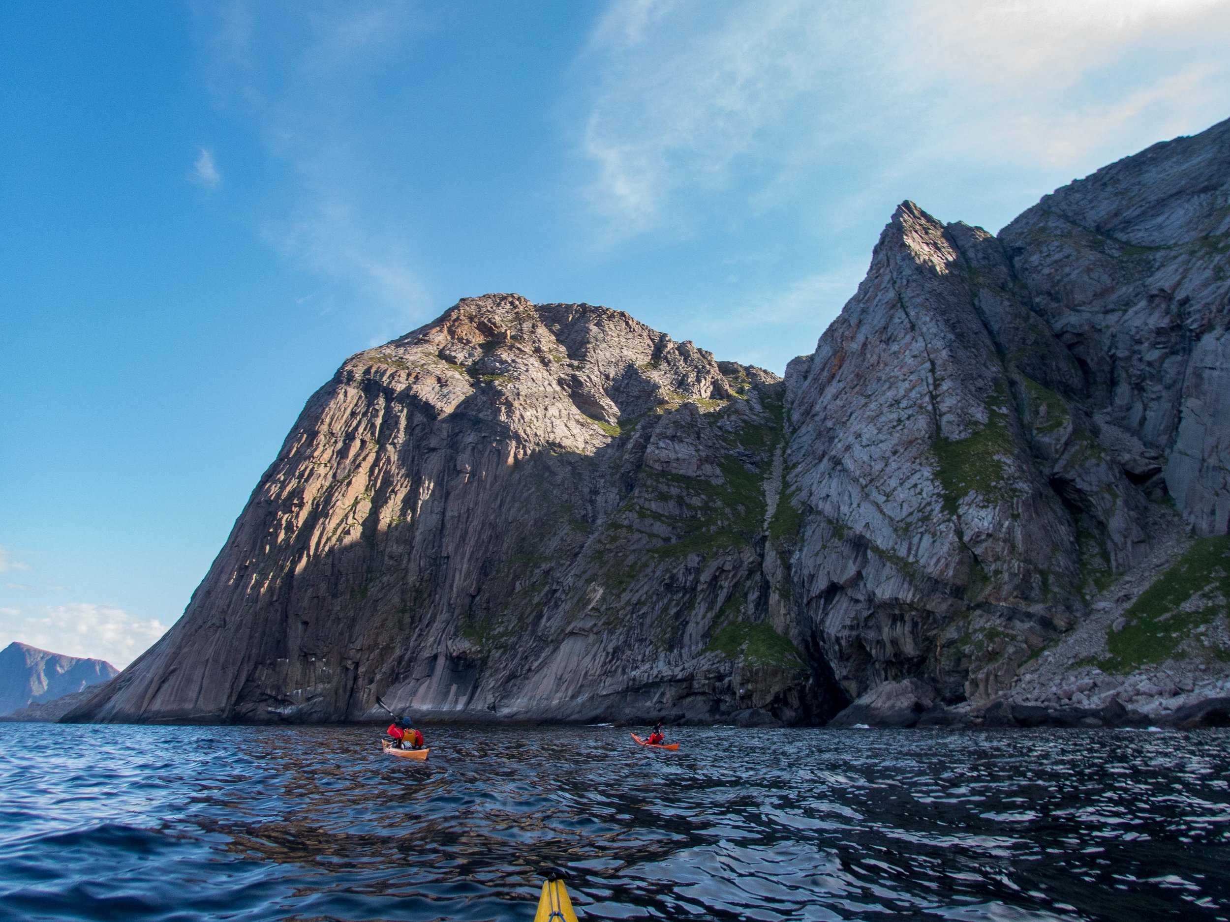
A bit after 4 p.m. in the afternoon, the current should have subsided to less than 2 knots, and we launched shortly after the Hurtigruten came south on schedule. It turned out to be quite easy, as there was no opposing wind and we could paddle at more than 3 knots in the eddies along shore. Once past the pinch point, we continued south and headed over to the Trollfjorden for some sight-seeing, as there was still plenty of daylight. The Trollfjorden was indeed a treat, albeit a bit busy with a few tourist boats and local sailboats. We marvelled at the tremendously high cliff faces, following Jann’s advice not to paddle too close due to risk of falling boulders. We paddled most of the way in before turning around and heading for our campsite at Brakøya Island. In spite of our tide miscalculation, we landed at ~8:30 p.m. and were in our sleeping bags before 11. A great day!
Trollfjorden Slideshow


Day 13: Brakøya Island to Sandøya Island: 8.3 nmi / 15.4 km
It was quite hot in the morning as we packed up our tents and gear, and I decided to try paddling with my drysuit top rolled down. However, after only ~1 nmi the southwest wind increased to over 15 knots, and that plus the opposing flood meant that we were making slow progress. We continued battling our way south, eddy-hopping and hugging the shore as much as possible. After lunch and a rest, we continued, and when making a crossing to the east side I had trouble with my skeg, and quickly got blown and pulled to the other side against a steep ferry angle. That corrected, we paddled on, and decided to look for a campsite in the afternoon, rather than battling our way across the channel to Svolvær. We found a nice spot on a little island named Sandøya, and we were relieved to get a break from the wind. On the way in to our island, we saw dozens of large sea eagles circling overhead and perched on small trees on nearby islands. My clothing was soaked from perspiration when I finally changed in my tent. Right before dinner, it began raining for the first time since the day before our trip began. The forecast had predicted the increased wind and rain, but it was expected to abate by the next day. Such lucky weather!


Day 14, Last Day: Sandøya Island to Kabelvåg: 9.5 nmi / 17.6 km
The rain had subsided in the morning, and paddling conditions were much more favorable: cooler temps, grey skies with a light headwind. As we turned to paddle due west and began our ~ 5 nmi crossing, we could see the buildings of Svolvær in the distance. We also saw a giant camo-painted military ship speeding toward us on an eastward heading. However, they slowed down to a low speed as they approached, proceeding past us at a slow crawl. We later learned from Jann that he had reported the sailors numerous times, such that they now faced stiff fines for excessive speed near kayakers.


We were exhilarated after landing back at Sandvika campground in Kabelvåg, and we convinced a visiting vacationer to take our picture. We had a celebratory lunch in between packing up and rinsing our gear, and Jann and his assistant Od were kind enough to pick up our gear and transport us to our hotel in Svolvær. We had a temporary ‘yard sale’ on the front lawn, while we sorted and dried gear for the flight home.


This sea kayaking expedition in the Lofoten Islands of Norway was an absolutely fantastic paddling vacation that was blessed with extremely fortunate weather. I fell more in love with Norway than when I first arrived, and already wanted to come back to spend more time in some of the locations we paddled past. There is so much to see and enjoy in the Lofoten Islands, particularly on the north side! The excellent weather and settled conditions allowed us to make a fairly easy circumnavigation of the islands without many high-mileage days. I highly recommend Jann Engstad and his staff at Lofoten Aktiv for their support, integrity, attention to detail, and of course their friendliness. Kayaking in the Lofotens offers something for every level of paddler: the south east side offers island camping in the area east of Svolvær, and the trip to Å is fairly well protected, with numerous places to shelter in the event of wind. The northern side offers great adventure for experienced paddlers comfortable with potential surf landings, Force 4-5 winds, and more confused seas, as well as navigation and camping in remote locations. The sights are spectacular throughout the islands, and we found the Norwegians to be incredibly friendly, kind, and helpful. This is a close tie with Iceland for my favorite sea kayaking expedition!
Except where indicated, photos by Cris Lewis: Olympus TG-6, Canon Powershot 50HXS
REFERENCES, LOGISTICS AND NOTES
*All mileage is provided from GPS tracking, which will be a slight overestimate of actual mileage.
(1) “Moskstraumen” on Wikipedia.
The best reference source for paddling the Lofoten Islands is Jann’s book, written by Jann Engstad and contributing editor Olly Sanders. “The Lofoten Islands: A Sea Kayak Guide to the Magical Isles”, published by Jann Engstad, 2016. ISBN 978-1-78280-910-4. The book is outstanding, probably the best sea kayaking guidebook for an area that I have ever used. In addition to detailed descriptions of paddling areas, he has several campsites and launch points with GPS coordinates, and detailed descriptions of the area history, geography, culture, and ‘watch-outs.’ In addition to many photographs, there are maps and detailed descriptions of areas. The book can be purchased from Jann’s website, Lofoten Aktiv, which is also helpful. Needless to say, I highly recommend Jann and his company! The quality of his boats, gear and support was absolutely outstanding.

Jann Engstad

The 1:50,000 Lofotodden charts that Dick and Kim used were high-quality and printed on weather-resistant paper; I recommend them for a good high-level view, and these are probably best for reference while paddling. The reference numbers are 10132, 10133.
I found the website the Norgeskart provided an online map with excellent detail. While a bit slow to load, the topo and marine detail is very good. I like having marine bouys and lights on my daily charts. I chose to download many pages of printouts of this map at 1:25,000 and piece them together. While it was great to have the extra detail, this system wasn’t very convenient for on-the-water reference, as it required me to change maps once or twice per day. In addition, I didn’t print it on waterproof paper or laminate it, due to the total number of pages, so it didn’t last long. But it certainly served its purpose during the trip, and was a nice complement to the 50K maps during our chart séances.
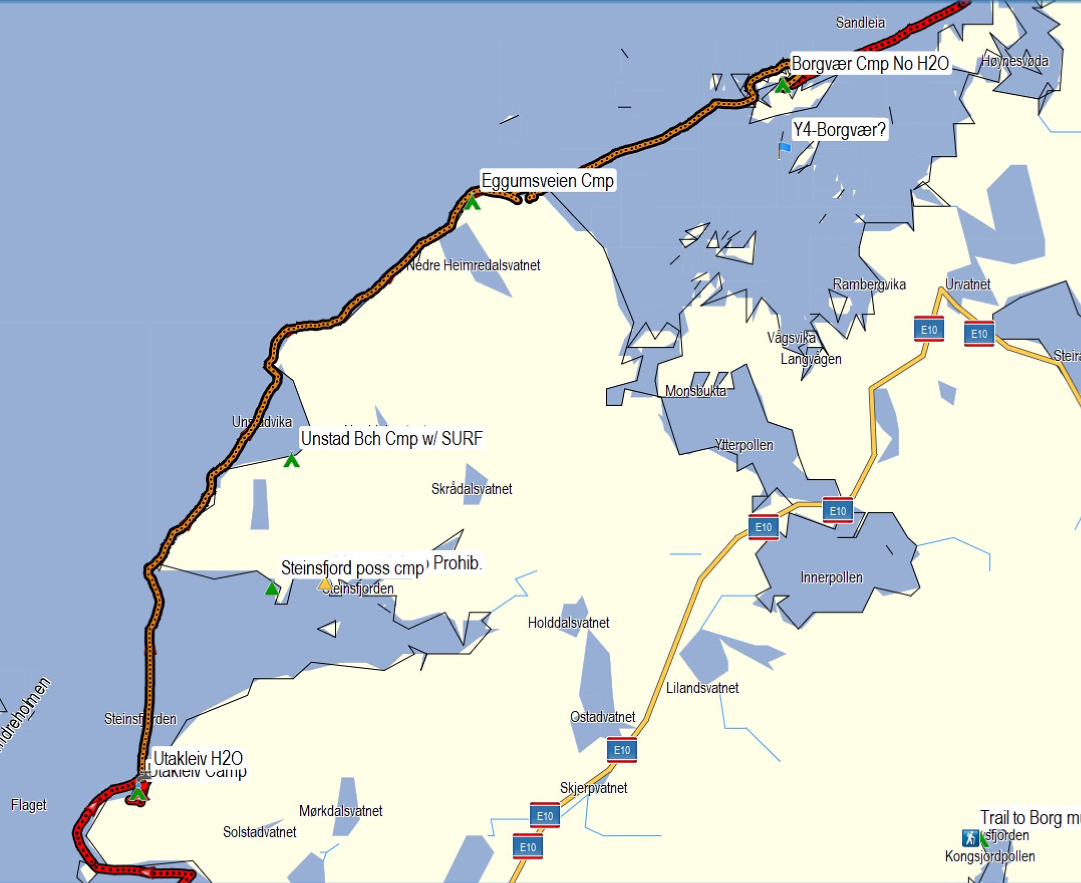
For planning, I also used this online map that showed details of campsites. These campsites are more geared toward camper vans, but the information is nevertheless relevant. We steered clear of areas where camping was not permitted, even if they might have been mentioned in Jann’s book. The campsite areas are constantly evolving with land use and development.
The best source of weather for the Lofotens is the Yr.No App, which we downloaded onto our iphones and used throughout the trip. Cell reception was sufficiently strong throughout our trip, with the exception of the preserve area between Lofotodden and Horseid Beach. We used our existing cell plans or a pre-paid SIM card that used whatever local cell tower provided the best signal.
Feel free to download and share this GPX file of waypoints and campsites. Possible campsites, designated with green tents, and green or yellow triangles, were just some of the many waypoints provided from Jann’s book, or selected from the Norgeskart map and Google Earth, with input from this website that listed areas where camping was not allowed. Detailed information on water, campsites, and more can be found in Jann’s guide book.