RAIKURA TRACK

My love of the ocean prompted me to visit the Rakiura Track, one of New Zealand's Great Walks located on Stewart Island, on the southern tip of the South Island. The larger, multi-day tramp circumnavigating all of Stewart Island has a reputation for being extremely muddy and wild. I chose the shorter, 3-day version: a loop starting and ending in Halfmoon Bay of Stewart Island. The forecast was for heavy rain for two of the three days, but there was little elevation change.

LEFT: Stewart Island location on the South Island of New Zealand
ABOVE: The Rakiura Track Great Walk, in Blue

36.3 km, 3 days
GPS track, in blue, of the Rakiura Track 3-day trip. (My GPS batteries died twice, so 2 short parts of the route were added later.)
Day 1 -- Halfmoon Bay to Maori Beach Campsite 10.1 km


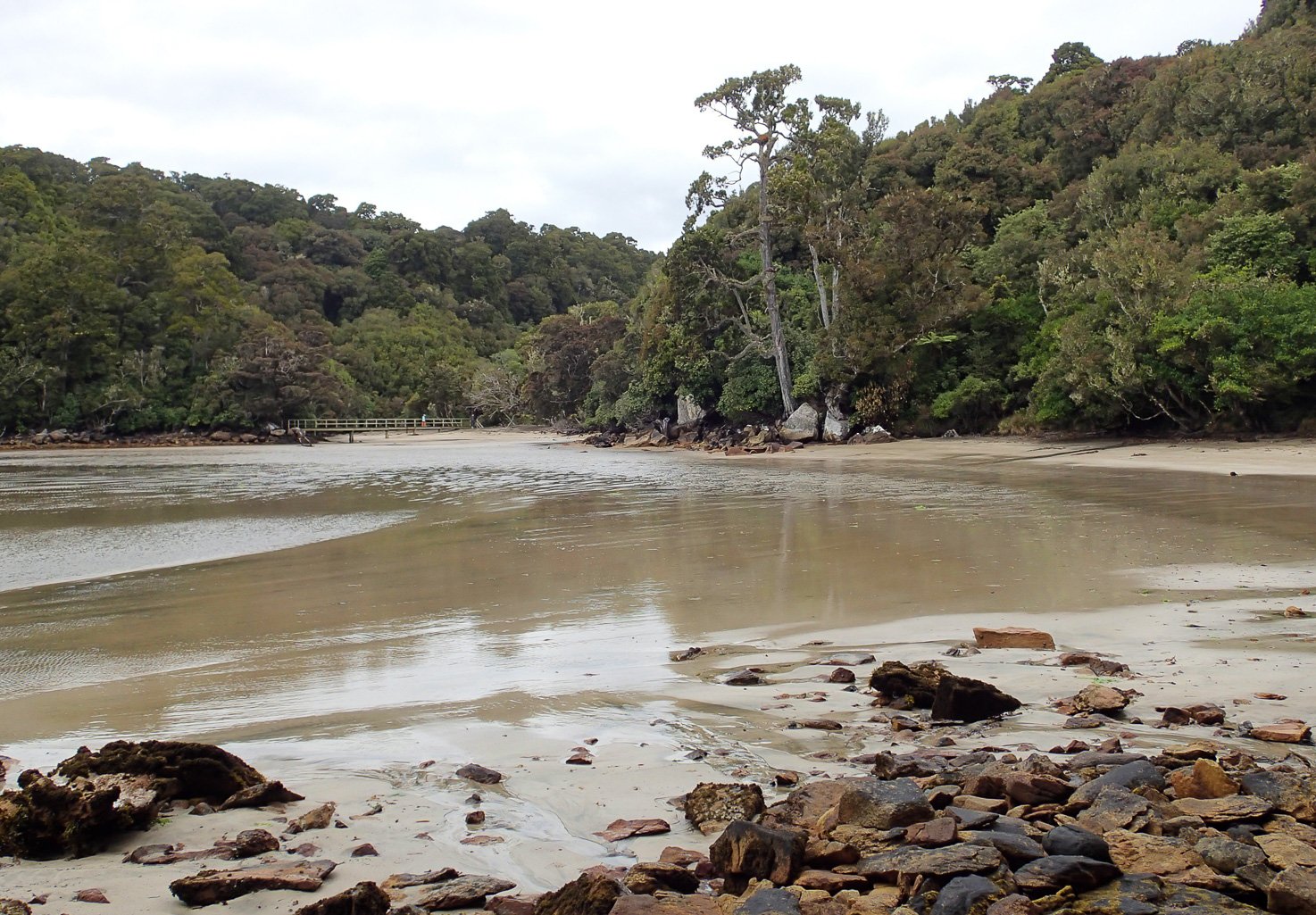
The Halfmoon Bay harbor
After spending more than a week in my rented camper van trying to overcome a virus, I was feeling better but still low energy, with a persistent cough and sore throat. (In retrospect, I believe I had been infected with the Covid virus, announcement of which had just emerged on the international news.) Mentally, I was eager to start hiking the 3-day Rakiura track and figured I could do the hike on the dates I had reserved seven months earlier. In a light rain, I drove to Bluff on the southern tip of the South Island, and parked my camper van in the long-term parking lot there. I caught the 9:45 a.m. ferry across Foveaux Strait, for a 1 hour crossing to the Halfmoon Bay harbor on Stewart Island. The water was calm with a light breeze, and the sooty shearwaters were flying low over the waves in graceful arcs. I was happy to be back near the ocean again.
Good luck prevailed: The rain stopped just as the ferry arrived in the harbor. After checking in at the DOC site on Main Street, I began the walk on the town streets to the start of the track. The walk to Lee Bay was pleasant, with rolling hills and a side track to bluff views over the harbor.

Idyllic Horseshoe Bay, en route to the Rakiura Track
At the start of the track, I saw the iconic symbol of Stewart Island's Anchor Chain "Te Puka", symbolizing the Maori legend of a chain anchoring Stewart island to the mainland. The counterpart chain and anchor lies in Bluff, 30 km across Foveaux Strait.


The beginning of the track was very well maintained, with pleasant views from the forest out onto bays. The tide was low, so I was able to take a shortcut across the beach to rejoin the track at Little River.

Above: I was happy to see that the endangered kiwi was living wild on the island.
Right: The beach at Little River
I arrived at the wonderful Maori Beach campsite in the early afternoon, and had the entire campsite to myself until later in the evening, when 3 more people joined. This was a delightful beach campsite with a sheltered cooking area and a fantastic view. Although I had to carry extra gear, I was happy with my choice to camp rather than stay in huts. And my luck continued; the rain did not resume until 10 minutes after I entered my tent for the night.

The delightful Maori Beach campsite
Day 2 -- Maori Beach Campsite to North Arm 13.8 km

The rain continued throughout the night and there was a steady rain in the morning, consistent with the forecast. I packed up leisurely and didn't depart until mid-morning. The trek began with a walk down Maori Beach to the suspension bridge at the west end of Wooding Bay.


This sign at the start of the suspension bridge made the consequences very clear!
Then began a long hike into the forest, heading west toward North Arm. This turned out to be one of the least pleasant backpacking days I've experienced: the trail was quite muddy and mucky, with muck and mud pools up to knee deep. A new mud bog appeared every 200 meters or so, requiring one to simply wade in, or try to find any areas of slight elevation across narrow strips of path. It made for slow and tiring progress as it continued for the entire 11+ km. Other than a 15 minute lunch break, I hiked slowly for 7.5 hours in the forest. Although the forest trees of podocarp and rimu were beautiful in the rain, the mud and my low stamina dampened my enthusiasm.


I did stop briefly at the historical preservation of the old, discarded steam engines used to log this beautiful forest. These are not unlike abandoned steam engines I've seen in the Pacific Northwest (see Haida Gwaii trip).

The forest had plenty of running streams and a few waterfalls, which were fairly active and picturesque in the steady rain.


I finally arrived at the North Arm campsite, where a few tent sites were still available. There was a large shelter for cooking and a clean long-drop loo. The ranger circulated through the campsite as evening fell, warning us about leaving anything outside our tents because of the marauding possums. Unlike the North American Opossum, the non-native New Zealand possums are more attractive black, furry, cat-like creatures. Just after dark they were knocking over any loose pots and pans in the shelter, and when I visited the loo in the wee hours, I saw several pairs of eyes glowing in my headlamp. There was apparently a family of three kiwis living nearby, and although I didn't see them, I was thrilled to hear them cry in the night. Kiwis only emerge after dark, and I was too tired to go searching for them on the muddy trails.
Day 3 -- North Arm Campsite to Halfmoon Bay 12.4 km

I slept poorly the previous night, with a bad sore throat and more coughing, but was able to pack up in a light rain and hit the trail around 9 a.m. There were much fewer muddy patches on the east-bound trail, which was a relief. This part of the hike was more pleasant, with gentle undulations and peek-a-boo views of Foveaux strait or ocean bays.


I stopped for a long lunch at Kaipipi Beach (below) and enjoyed the rest and the view. The intermittent rain was quite light, easing for part of the day. I was feeling unusually tired and regretfully decided to forego the extra 1.5 hour detour to Ryan's Creek, which would have allowed more ocean views. Although I had the time, I didn't have the energy. After emerging from the track at the Fern Gully park, I walked on the streets of Oban back to the DOC i-site. After washing up at the DOC i-site and treating myself to a cold soda and a bag of chips at the Oban corner market, I just missed the 3:30 p.m. ferry to Bluff. I didn't mind just relaxing in the terminal until boarding for the next ferry at 4:45 p.m.

The ferry ride back to Bluff was quite different from the ride over! According to the first mate, the winds were up to 25-35 knots, and the waves were just hammering the boat on the port side. Apparently an ebb was compounding the swell, with 2 meter wind waves. The ship captain, a woman, did an outstanding job navigating us through the storm and the rough seas back to the harbor at Bluff. The seas truly lived up to the "roaring forties" reputation, and it was fun to watch from the warmth of the boat's interior.
When I returned to civilization in Invercargill, I learned that many roads in the South Island were flooded due to the rains, and I would have to scout through several detours. Again, I felt lucky to have been able to complete the short Rakiura Great Walk, in spite of the mud, rain and illness.
The Rakiura track is unique for offering an island experience. I can't say I can highly recommend the Rakiura track as described by the New Zealand Department of Conservation. For those with a desire to camp in Stewart Island, I think a more enjoyable time could be had by hiking from the ferry to Maori Beach and camping there for one night. The second night could be spent returning to Oban to stay at a hostel, and another day could be spent hiking the Ryan Creek detour, and then back to Oban. The forest views in the interior from Maori Beach to North Arm were, in my view, not worth the arduous slog through the mud. I regret not allowing extra time to go to nearby Ulva Island, renowned for its birds and wildlife, but that would also be worthwhile to visit.
LOGISTICAL INFORMATION and PLANNING
Photography by Cris Lewis, Olympus TG-2
Department of Conservation of New Zealand: The DOC oversees all the hiking tracks and conserved parks and land within New Zealand, and they are a well-run operation! Nearly every question you may have about the Rakiura track can be found online at their detailed websites. I mention here a few details not obvious from those websites.
Stewart Island Experience operates the catamaran ferry from Bluff to Stewart Island. It is not cheap, at ~ $90 NZD one way. Cars can be parked for several days in a secure parking lot near the Bluff ferry building, for a ~$45-50 NZD fee, payable by credit card in an e-kiosk. In February, I had no problem finding a parking spot for the 9:45 a.m. ferry, but it might be busier earlier in the season or later in the day. The staff at Stewart Island Experience can also address the question of available spaces for long-term parking. I had no problem with theft at any time in New Zealand.
The DOC i-site on Stewart Island is on Main street, in easy walking distance from the ferry terminal. Although I saw no supermarkets in Oban, there is a small Foursquare market with a few essentials. Similarly, Bluff on the South Island is a very small town. Plan on bringing whatever you need for your trip with you. Invercargill, about 30 km away, is much larger, with supermarkets and camping supply stores.
If you plan to hike the Rakiura track, wear gaiters, boots, and pants / raingear that you don't mind being permanently altered by mud.