Glacier National Park: Bowman to Janet Lake & Hole-in-the-Wall

It had been many years since my last backpacking trip in Glacier National Park, and I was lucky enough to have the ability to visit some National Parks in 2024 on a grand road trip. I had tried to get permits for the coveted Northern Circle Loop, and even got access to the early Lottery system for Glacier National Park, but just wasn’t able to get the prized Fifty Mountain site to make the trip work. So I got a permit for my backup trip, from Bowman Lake Trailhead east to Janet Lake, with a side trip to Hole-in-the-Wall campsite. The trip was set for late August. My plan was to drive to Glacier from the San Francisco Bay Area, backpack in Glacier, then drive south to Yellowstone National Park for a second backpacking trip, followed by some wolf-watching and sightseeing in Yellowstone. The forecast was quite favorable with little or no rain, and it was quite warm. This 5-night backpacking trip was indeed iconic, and I was looking forward to seeing flora and fauna that were different from California.
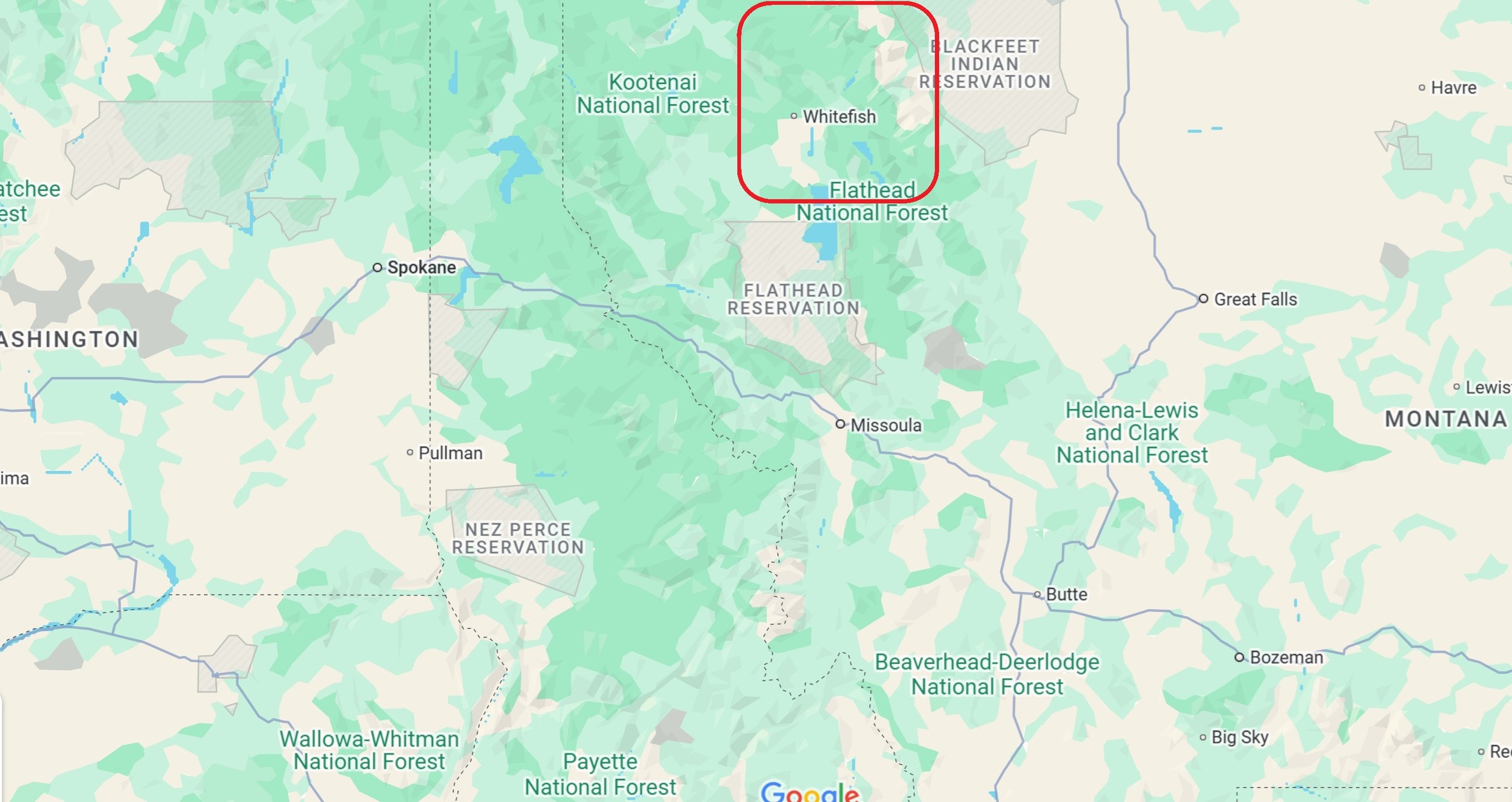
Location of Glacier National Park in Montana

Altitude change for the entire trip

GPS Track of the backpacking trip from Bowman Lake to Lake Janet
After driving up from the San Francisco Bay area, I arrived at the West entrance to the park at Apgar just a little too late to stop in at the ranger station. I camped overnight at Fish Creek Campground near Lake McDonald, which was convenient. The next morning, I was in line at the ranger station at Apgar before 6:30 a.m., and there were already 3 people in front of me, including one fellow who apparently slept there and had his partner stop by in the morning. Although my hope was to see if I could snag a last-minute permit for the Northern Circle loop, two of the people in front of me got the last ones for the day. So that may be the answer for those rare permits. Nevertheless, I was happy because I was able to get a campsite at the coveted Hole-in-the-Wall (HITW) site on my second night, an improvement over my original permit that had me visiting HITW only on a day visit.
Glacier National Park is home to both black bears and grizzly bears, so proper food storage is strictly maintained, carrying bear spray is required, as is watching a mandatory orientation video. Fortunately, heavy bear canisters are not required, and pole structures for hanging food are present at each campsite. When the rangers learned I’d be hiking solo, they wrote “Make Noise! :)” on my permit and highlighted it, after a verbal reminder.
I had some confusion about whether I needed an entry permit in addition to my backpacking permit (not on the west side, but yes on the east side), which caused further delay as I drove back to check (no cell service). When I finally made it to the Bowman Lake trailhead, there was some confusion about parking, as there were no long-term parking spots remaining. It was a relief to finally be hiking after the long drive and all the logistics. It was a beautiful, sunny day and many folks were enjoying their day at the lake.
Day 1: Bowman Lake Trailhead to Bowman Lake Head: 7.2 mi*
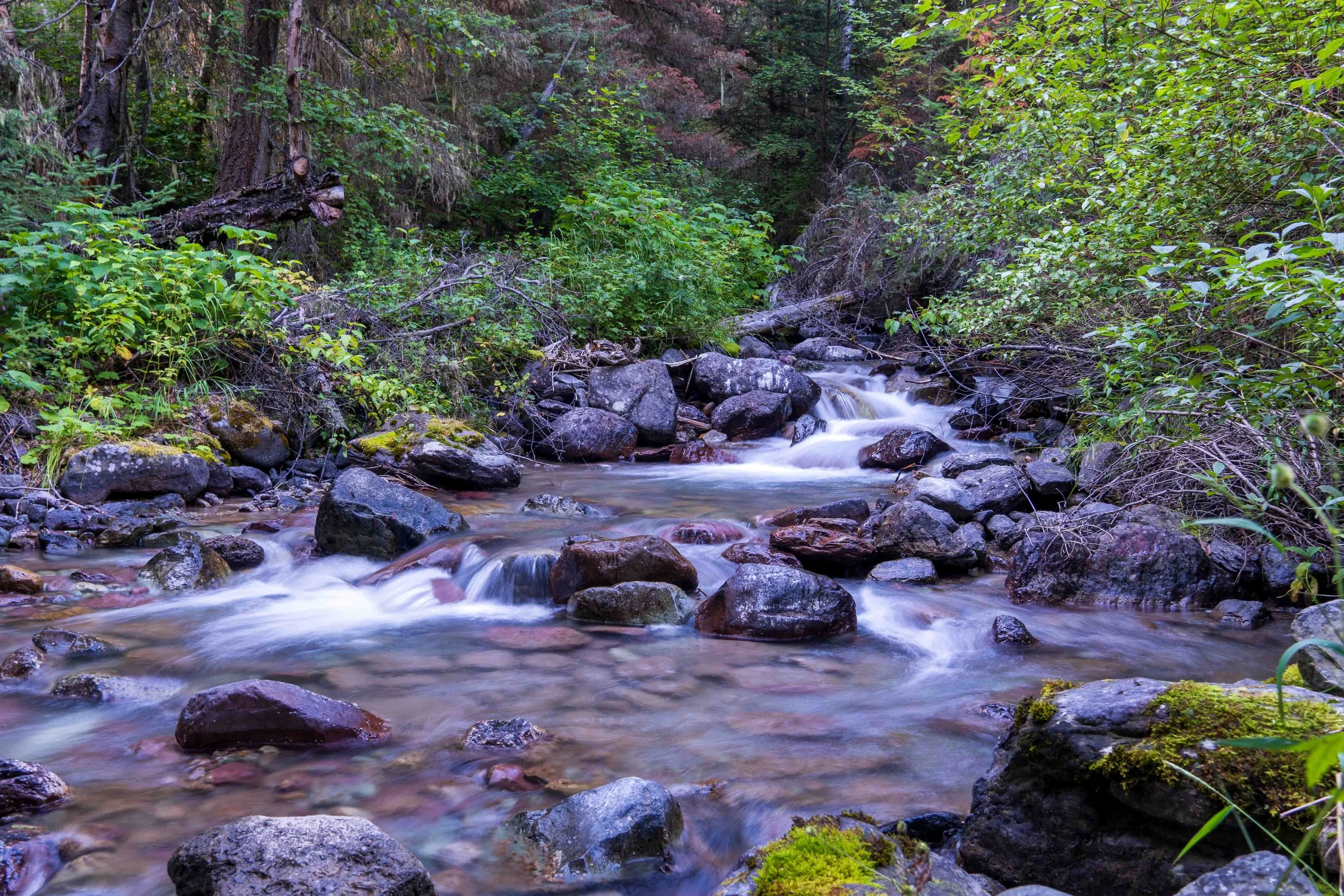
Even with a late start, this was an easy day of lakeside walking. There were a few places with views of the head of the lake, but most of the trail was more obscured. As the distance from the trailhead increased, the trail became more overgrown, but nothing compared to the following days, as I was to discover. The day felt warm, with temperatures in the high 70’s to low 80’s °F, but the shade and breeze made the trek enjoyable. After hanging my food on the handy pole structure provided at each site, I set up camp and took some long-exposure photographs of the nearby creek.

In the food preparation area that afternoon, several of us exchanged next-day destinations. A group had just hiked down from HITW, and I mentioned that I’d be hiking up there the next day. Several pairs of eyebrows shot up, and one woman said, “Oh, you’ll have a tough day tomorrow, in the heat.” Hmmm.
Day 2: Bowman Lake Head to Hole-in-the-Wall Camp 9.7 miles
I was on the trail by 8 a.m. the next morning, and I was feeling the start of a cold virus coming on. The first mile was easy, but the trail was surrounded by tall grass that was wet from recent rain. Soon my socks and leather boots (Lowa Renegade Gore-tex) were soaked through, squishing with each step. It was also hot and humid, with temperatures in the low 80’s. The real climb was between miles 3 and 7 or so, at approximately 500 feet / mile, so not terribly challenging, but made much worse due to the heat and exposure. Three to four miles of the uphill had minimal protection from trees and little shade. I took off my hiking shirt around mile 3, hiking in a sports bra only, which really helped. There was no water near the top of the pass at the Brown campsite, so I had to backtrack about a 1/3 mile down the trail to collect water there. After reaching the Brown campsite, there was a bit more uphill toward Hole-in-the-Wall, before descending into the campsite where the trail forked. The final 2 miles to the camp seemed longer than it should have, as it was very hot. I was able to snag a decent campsite with some privacy, but other campers were fairly close, and the last available campsite was out in the open with no privacy (but a great view of the night sky). I have to say, the heat took quite a bit of fun from the trek.


Day 3: Hole-in-the-Wall to Lake Janet 8.7 miles
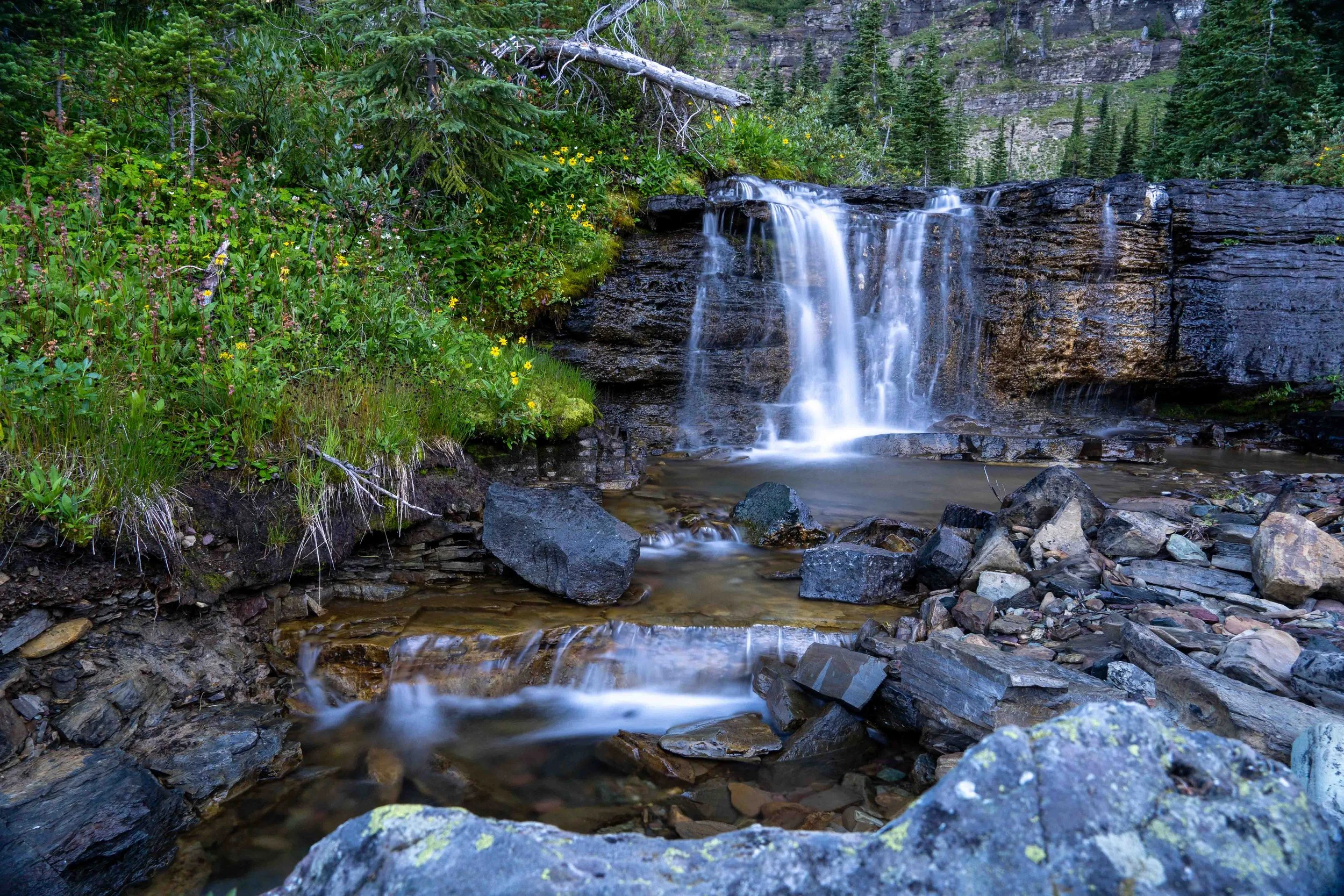
I had a leisurely breakfast and felt better after rehydrating from the previous day. I took the time to fool around taking photos of the nearby table-top waterfall near the camp. The day’s trip was easier, being mostly downhill, but some fatigue from my worsening cold made the mileage seem a bit longer. The trek was beautiful, filled with jaw-dropping landscape scenery. The weather was still hot, in the mid-80’s °F., but hiking without a shirt made it easier. I had a long, relaxing lunch at Lake Frances, which I had to myself. This campsite is difficult to reserve, understandably.
After setting up camp in the small campsite about 0.5 mile west of Lake Janet, there was some thunder and light rain for a while, so I caught up on my notes in my tent, then hiked out to Lake Janet for more sightseeing after the light rain stopped. It started raining again just after dinner, and I was asleep in my tent before 9 p.m.
HITW to Lake Janet Slideshow


Day 4: Lake Janet to Brown Pass 6.1 miles

After the heat of the last two days, it was somewhat cooler, but still in the high 70’s °F. and quite warm for backpacking. I was feeling a bit worse from my cold, and knew I had to climb out of the valley to Brown Pass in the heat. The grass and bushes were quite tall (over head high) on the way from the campsite past Hawksbill and Lake Frances, so my boots got soaked again. I tried the trick of putting newspaper baggies over my socks, which helped to keep the socks somewhat drier. At the bottom of the climb at the pond that was the outflow of Thunderbird Creek, I stopped to fill up my water and remove my shirt for the climb. It turned out to be easier than I expected, as it was shady with lots of switchbacks. I was at the top in no time after a short lunch near the top, and was setting up my tent at Brown Pass campsite in the early afternoon. Not too many photos, as I was retracing my steps.
Day 5: Brown Pass to Bowman Lake Head 7.1 miles

A last look at the mountains before descending into the valley in the rain.
While having breakfast with some Montana locals in the food preparation area in the morning, we all noticed the ominous clouds filling the sky. Sure enough, a light rain began before I got a mile down the trail toward Bowman Lake. But my pack was lighter, and it was all downhill. But I was really kicking myself for not bringing rain pants! I was hoping to save weight given the nice forecast, but at least this is a mistake I won’t repeat (unless I’m in California during the summer)! I had my camera packed up for the entire hike, and my pants were once again soaked by the time I got to camp at Bowman Lake. I was hungry around 1 p.m., so I made the mistake of stopping for lunch instead of hustling to camp. Shortly after resuming the trek, the rain increased and it began hailing. I was soaked from the thigh down as I was hanging my food in the rain, my teeth chattering from the cold. I was happy to get into my tent and put on dry tights and socks.
Day 6: Bowman Lake Head to Trailhead Exit 7.1 miles

Fortunately, my quick-drying pants were dry in the morning, and there was no more rain. Morning fog blanketed the lake as the sun began peeking out behind the mountains. The flat trail made for an easy trek out, and I saw quite a few folks meandering east as I got closer to the trailhead. My boots dried out partially during the hike out, and I learned that it’s not fatal to hike in soaked socks and boots. I emerged muddy but wiser, exhilarated at having the opportunity to complete this trek amid such amazing and inspiring landscapes.
Glacier National Park is truly a unique gem in the collection of U.S. National Parks. The landscape vistas on this trip, from the long stretch of Bowman Lake to the towering mountains and glacier-filled summits, are spectacular. I enjoyed the challenge of this trip that required hiking from lake level up 2400 feet to mountain passes. Carrying the extra food of a six-day trip was not too arduous, although the summer heat made the climb to HITW more challenging. I was disappointed not to have seen more wildlife, but the hot summer sun may have caused more animals to hide out in the shade. As a solo hiker, I had to do an out-and-back trip, but most groups hiked the “horseshoe” half-loop, entering from Kintla Lake and exiting at Bowman Lake (or vice-versa). I highly recommend this trip as one of the must-see backpacking adventures of the park - you won’t regret it!
Photos by Cris Lewis Sony alpha 6600, 18-135 mm lens
*Mileage reported is as captured by GPS track, and may be an overestimate of actual mileage.
LOGISTICS AND TIPS
The small lot for long-term parking at Bowman Lake may be full. I learned from another backpacker that the ranger (nowhere to be found during my visit) told them to “just park in one of the more crappy sites in the regular campsite loop.” That’s what I did, and had no problems for the 6 days I was out.
There is no shuttle for the more common “horseshoe loop” between Kintla Lake and Bowman Lake. Groups leave a car at each end, or hitchhike.
Campsites: The tent sites at Bowman Lake head are fairly well spaced apart and offer reasonable privacy between sites. The privy was in good shape there. Although the Brown Pass area offered great views, the tent sites at Brown Pass were nothing special, and had little privacy between sites. One could hear nearby campers easily. The primo campsite at HITW was the westernmost and last on the trail, after hopping across the creek that supplies water. Unfortunately, it was already taken when I arrived. Lake Frances had very nice campsites, given the incredible views and the opportunity for exploring a bit around the lake. This is a coveted site and difficult to reserve. The sites at Lake Janet are not near the lake at all, but have only two tent sites nestled in trees on the north side of the trail. But Lake Janet itself is fairly shallow and therefore more fragile. It is also replete with wildlife, judging from the tracks I saw in the beach sand. Every site had an upside-down U-shaped metal bear pole, which required throwing a rock over to hang one’s food (practice makes perfect).
Local Montana residents report that weather forecasts in the area are notoriously and absolutely unreliable, given the mountainous weather systems. I have learned my lesson to bring all rain gear even for a favorable forecast: these mountains are not the dry and reliable summer California Sierras! Also, after this trip I began having second thoughts about my beloved Lowa Renegades: the leather later shrunk after drying out, which negatively affected my subsequent hikes in Yellowstone National Park. I invested in boot stretchers when I got home, and am now considering whether trail runners offer too great a potential risk for ankle injuries on long solo journeys. Feel free to comment below based on your experience.
Grizzly bears are common in Glacier National Park, and the threat is real. During my previous visit many years back, a father and daughter were severely injured when they surprised a Grizzly sow as they rounded a corner. They were attacked, mauled, and knocked down a hill. Several serious attacks have happened in subsequent years. The rangers take the threats seriously and take great pains to educate hikers. Carrying bear spray is mandatory, as is hanging food. As a solo hiker, I was encouraged to make noise, and I did just that. Although I am someone who prefers quiet in the wilderness, I got over my tendency for hiking quietly on my last visit. Although bears generally prefer to have little to do with humans, a startled bear is a dangerous bear. I alternated between clanging my trekking poles together and saying “Hey Bear” in a loud voice, particularly when entering brushy areas with head-high coverage, rounding a blind corner, and every so often along the trail. The little tiny “bear bells” that jingle when you walk are worthless; they’re simply not loud enough, and the rangers discourage their use altogether. Having said all that, I would have preferred to see a Grizzly, from afar.