Broughton Archipelago, East Vancouver Island

Orca Pod in Blackfish Sound Photo by Ken Sund
The Broughton Archipelago is on many lists of world-class sea kayaking destinations, and it seemed a great time to explore this area on a relaxing, low-mileage expedition with my paddling friends Mary Ann Furda and Ken Sund. It offers an opportunity to see orca killer whales and protected waters for kayak glamping at its finest!
Route Overview: 116 miles, 12 Paddling Days

The Broughton Archipelago off of East Vancouver Island

We chose to launch from Alder Bay resort, as it was less busy than nearby Telegraph Cove, and offered safe long-term parking for a modest fee. It was a long drive up from the San Francisco Bay Area to Otis, Oregon, where Ken lived, and then to Vancouver Island via the Black Ball ferry from Port Angeles, Washington.
We arrived early enough to take the Port McNeill ferry to the U’mista Cultural Center museum on Alert Bay. This was a gem of a museum, with very well-organized and thoughtful exhibits, all rich with detail and cultural artifacts. Particularly poignant was the description of the large “White House” that housed the children of the Indigenous population that had been removed from their parents in the infamous re-culturization efforts. Check out the Bansky-like (original?) artwork that is part of the exhibit. I highly recommend this museum!
We had time in the evening to set up tents and do some final preparations for our launch the next morning.

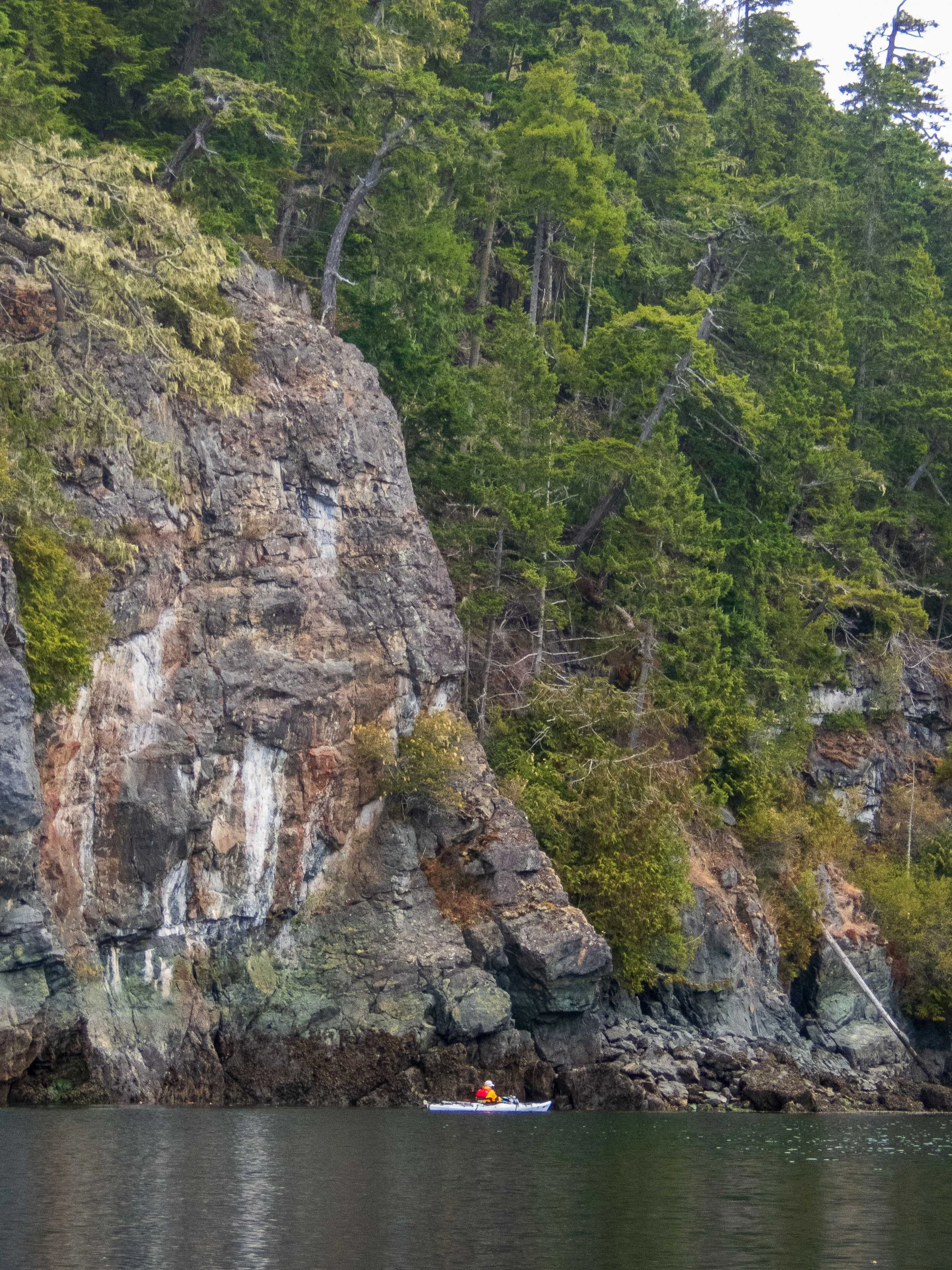
Day 1: Alder Bay to Maggy Islets — 11.6 nmi / 13.7 mi / 22 km Although it rained overnight, it had stopped in the morning, and we launched in cool, grey fog to paddle east toward Blackfish Sound. While the Broughton area offers protected waters, there are significant currents in the southern entrance areas north of Johnstone Strait that require a paddler’s attention. I had planned the timing of the trip such that we could arrive at the Plumper Islets at slack, thus avoiding the tide rips there. Waters were calm, and we rounded the Plumper Islets and landed in a small cove for a quick lunch. I stopped to photograph some lovely Harlequin ducks hanging out in the cove.
I was also conducting campsite surveys as part of my role as a Coastal Caretaker for the BC Marine Trails organization, but I was yet to discover the quality of the campsites in this area - wow!

As we paddled east into Blackfish Sound, we were thrilled to see a pod of orcas approaching us! We did our best to snap some photos and enjoy the moment, feeling so lucky to have seen orcas on our first day.


We counted at least 7 tents on the Flower Islets, so we proceeded east to the Maggy Islets to set up camp. These protected little islets offered a wonderful campsite, with cedar-planked tent pads and a makeshift kitchen area set back from the shore.
Day 2: Maggy Islets sightseeing to Pearl Island — 6.4 nmi / 7.4 mi / 11.8 km Ken and Mary Ann chose the paddle plan for the day, with a hunt for the Chief’s Bathtub and it’s petroglyph, and a possible visit to Village Island. There was a forecast for gale winds in the afternoon, so a shorter day was probably wise. We had a leisurely launch on a cool morning, and paddled east through Village Channel in search of the sights described in the Kimantas guidebook to the area.


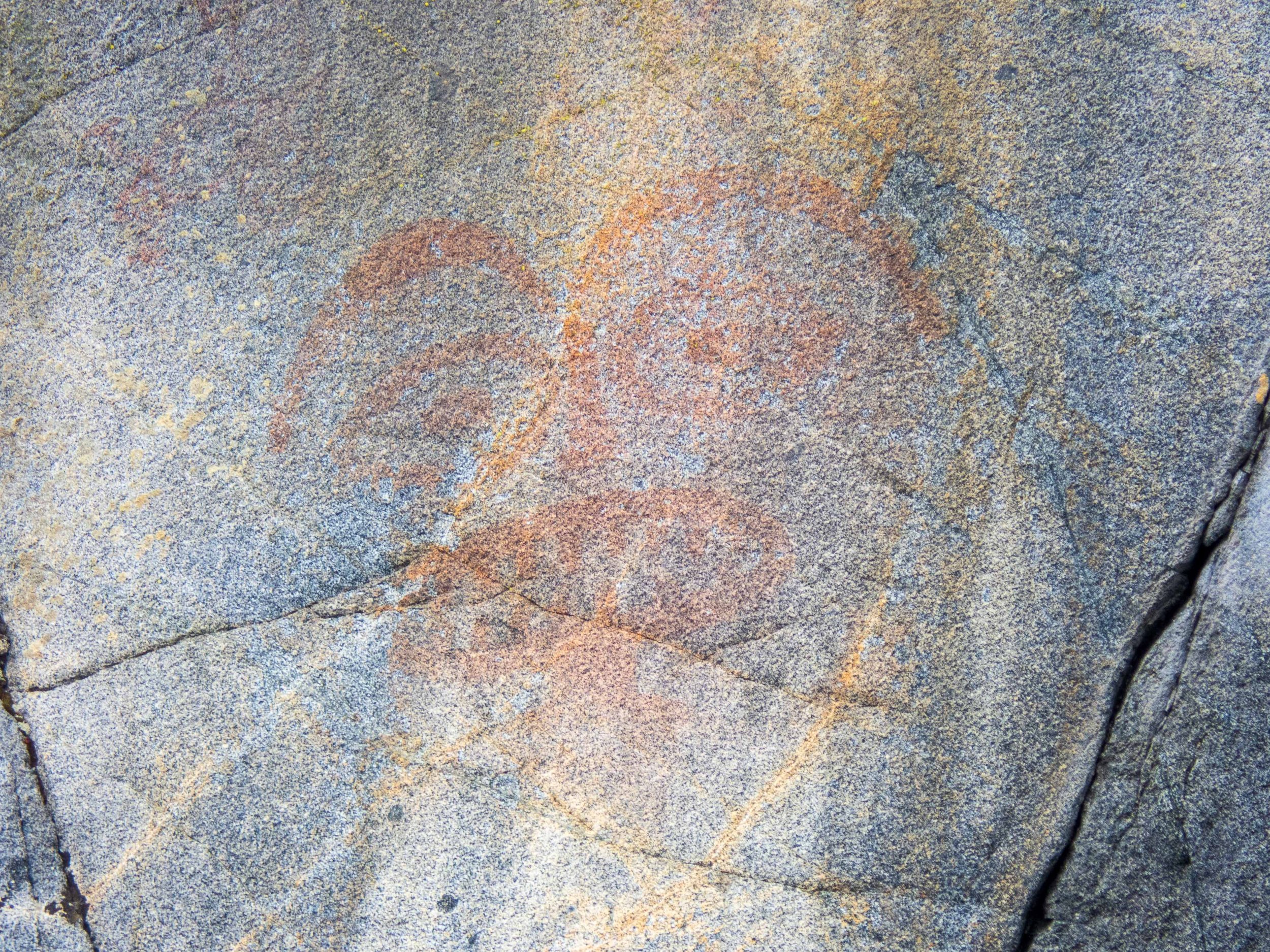
We soon found the “Chief’s Bathtub”, a feature in the rock wall allowing a soak in sun-warmed ocean waters, and just a little further east, the pictograph on the rock face (not a petroglyph).
We stopped for lunch on Village Island, but were unable to reach anyone at the number or email on the sign, using either cell phone or my Inreach device. We nevertheless left a donation, but I did not want to explore without explicit permission. We landed in the early afternoon at Pearl Island, for a relaxing time setting up camp and waiting to see if the gale force winds would materialize. We never experienced significant winds, even as the sun set behind the islands.


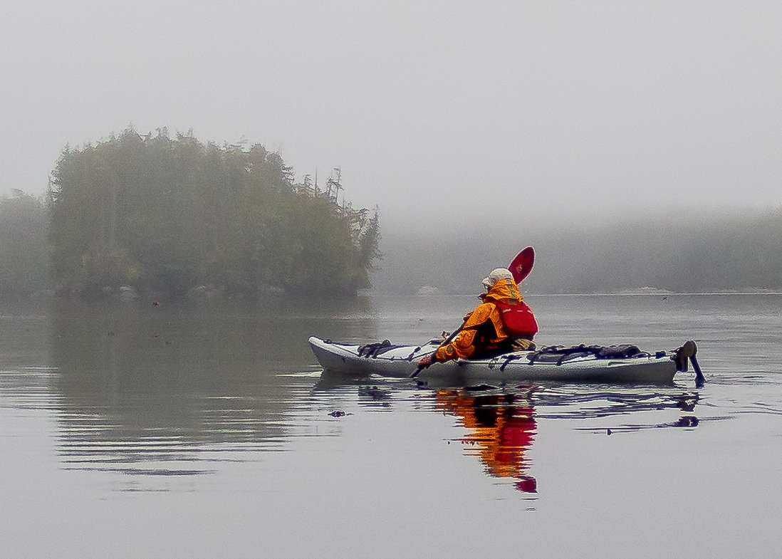
Day 3: Pearl Island to Fox Group — 9.4 nmi / 10.8 mi / 17.4 km We launched on a foggy morning, with the sun making magical sunbeams through the misty trees. Conditions were perfect for a peaceful paddle among the islands as we made our way north across Knight Inlet and through Spring Channel to the Fox Group of Islands. We arrived at lunchtime and decided to stay, given the covered cooking area and rain in the forecast (true glamping). We were amazed at the new cedar tent platforms, kitchen areas, and new composting toilet that had been constructed recently. The air was rich with the scent of cedar, and there were at least 11 tent platforms that could fit multiple tents. Later in the afternoon, a large group of SUP paddleboarders arrived, each with all their gear onboard for camping overnight. We moved to the smaller kitchen area to give them extra space.


Day 4: Island Exploration Day Paddle — 12.5 nmi / 14.4 mi / 23 km

This turned out to be a glorious day on the water, in spite of the cool grey fog and misty rain in the morning. The waters were calm and peacefully quiet, allowing us to bask among the wildlife and scenery. In the tidal-dependent passage between Mars and Tracy Islands, we met a nice couple in a double Pygmy wooden kayak that they built, who were also out enjoying the peaceful rainy morning. We had lunch on Crib Islet, then paddled to the west end to Kate and Hunt Islets to continue exploring. We spied some harbor seals stretched out on a ledge, and a cute little raccoon visiting the water’s edge.


After we returned to the Fox Group, seven more kayakers arrived as part of a guided group. We all shared the kitchen structure and gathered as much information as we could from the local guides. I was exhilarated by the day’s beautiful paddle, and eager to head further north the next day for less crowded environs.
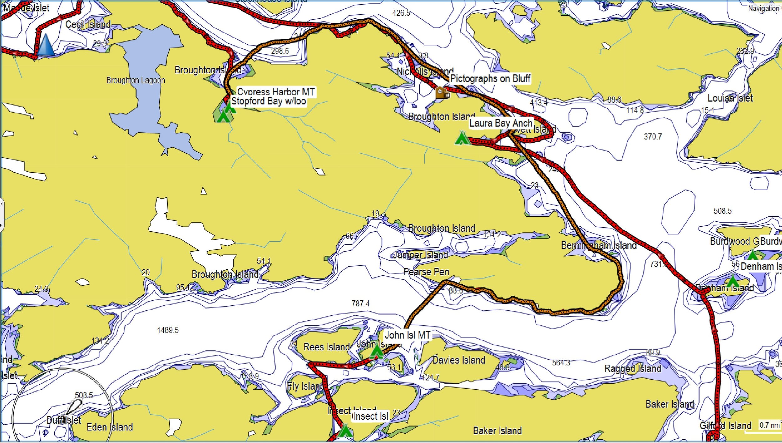
Day 5: Fox Group to Laura Bay — 13 nmi / 15 mi / 24 km We had a fairly early launch at 8 a.m., before paddling north in calm conditions under grey, overcast skies. Paddling north through Raleigh Passage, we stopped at Echo Bay Research Station, where we inquired about their studies as they kindly agreed to allow us fill our water bags.


After a stop at Denham Island and Village Point for lunch, we made our way to Laura Bay Anchorage. It was hot when we landed in mid-afternoon, and we stripped to our coolest clothes while setting up camp and doing camp chores. Tent space was somewhat limited, but I snagged a primo spot on a rocky bluff overlooking the bay. It was nice to be in a quieter campsite, albeit without all the new cedar amenities.

Day 6: Laura Bay to Greenway Harbor — 14.3 nmi / 15 mi / 23 km This beach required a long carry on a rocky and barnacled shore for our launch, and we paddled in a light rain and grey skies out of the bay and into Penphrase Passage.


Day 6 track (in gold) from Laura Bay to Greenway Harbor

Although we searched for the pictographs on a bluff as described in the guidebook, we were unable to find them. We found there were few places to land on these more protected rocky shores, so we finally landed on an unwelcoming beach near a log chute for some lunch. From there we made our way around to Greenway Harbor. Although there was supposed to be a marina facility there, nothing of the sort was to be found. We later realized it must have been a floating docked facility, the only explanation for its complete disappearance.
Day 7: Greenway Harbor to Cypress Harbor — 6.1 nmi / 7 mi / 11.3 km We hatched a fun plan to hike in the morning up to the two lakes on the established trail, then have a short paddle over to Cypress Harbor in the afternoon. The ~2.8 mile (round-trip) hike was delightful, through some overgrown trails, across a logging road and bridge, then along a drainage to Broughton Lake. Along the way, we came a cross a double privy - I had never seen one of those before and couldn’t really comprehend the attraction.
Greenway Harbor Slideshow


Track (in gold) from Greenway Harbor to Cypress Harbor
After our relaxing hike, we returned to our campsite to gather water from the creek before packing up. We launched a little after noon on under sunny skies. We faced an opposing ebb, but little wind as we made our way around the northern point of Broughton Island and into Cypress Harbor. This was a delightful campsite! It was very well maintained, with well separated tent sites (each with a picnic table), and a vault toilet. Mary Ann chose to sleep atop the picnic table for the ultimate in flat ground. The island was awash in bird sounds, and framed by colorful honeysuckle vines. It felt like a paradise all to ourselves - we had seen no one in the past 24 hours.


Day 8: Cypress Harbor to John Island — 13.2 nm / 15.1 mi / 24.4 km We faced an opposing current and a bit of wind as we made our way out of Cypress Harbor, but it was minimal hindrance for our progress as we hugged the shoreline. We stopped for a longer lunch break near Turret Island so that we could take the shortcut after the tidal passage flowed through. We checked out the small campsite on John Island, but Mary Ann and Ken were excited to try camping on top of the rocky outcropping. We set up camp and enjoyed the view and peacefulness in this quiet part of the archipelago.
Cypress Harbor to John Island (in gold)
The only challenge with camping on a rocky outcropping is that you have nowhere to go if the tide gets too high! Plus, it was near the full moon, so when I awoke at midnight, we had to move our tents, and it was a close call. Later in the night, we all had to rearrange the furniture again, and fortunately that was sufficient.


Day 9: John Island to Cedar Island — 10.6 nm / 12.2 mi / 19.6 km Needless to say, launching off this rocky outcropping was a challenge as well. We launched a bit later in the morning under cool, grey skies into a beautiful misty passage. Noodling between the islands in the protected waters made for a delightful paddle south. We saw a wall of starfish hanging on after high tide, a pod of dolphins, and quite a few pigeon guillemots. Cedar Island offered another nice campsite: an easy cobble beach with plenty of tent platforms.


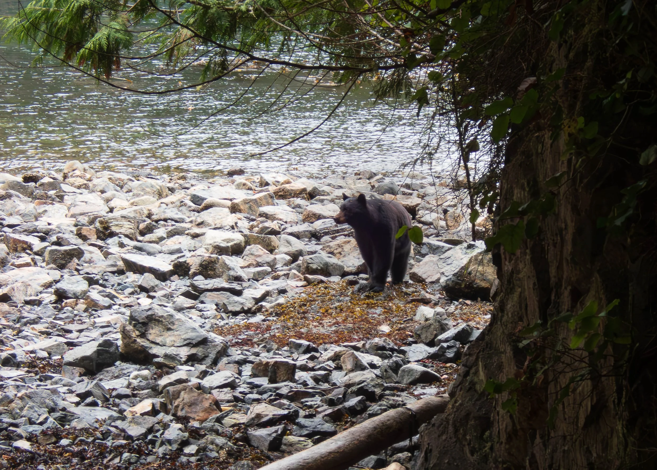
Day 10: Cedar Island to Maggy Islets — 7.8 nm / 9 mi / 14.4 km With little distance to cover, we took the time to paddle west to White Cliff Islets and land to explore. These would only be suitable for landing to camp at the highest tides, but were fine for temporary exploration. We climbed up the cliffs to enjoy the views before paddling south through the Wedge and Puzzle islands and a brief stop for lunch on Swanson Island. While I was checking out the campsite on Swanson Island, I spotted a bear after hearing his “chuff” on a forested hillside. He quickly disappeared from view, then I heard Mary Ann and Ken shout “Bear” as he emerged from the forest onto the beach area where they were sitting. They were initially alarmed when they saw the bear emerge from the forest, and didn’t see me! The poor bear was only trying to avoid humans, and we gave him his space as he loped across the beach and disappeared into the thicker vegetation.


We decided to return to Maggy Islets, as Flower Island was once again crowded. We also checked out the campsites on the nearby Crease Islets. These offered nice elevated and private campsites, but required a bit more of a walk with gear to the campsites that offered the best view. We were happy to be back in the familiar kitchen area of the Maggy Islets.
Day 11: Maggy Islets to Blinkhorn Peninsula — 9.4 nm / 10.8 mi / 17.4 km We planned to wait for close to slack tide before rounding the Plumper Islands, so we had a leisurely breakfast before launching and just drifting west with the ebb. We were hoping to view more orcas, but this was not to be. But we thoroughly enjoyed paddling and drifting through the glassy water, thanks to the absence of winds. We stopped briefly at Big Bay where we saw several kayakers that were part of a guided tour group. It turned out they were headed for Leg Cove, our intended campsite, so we opted to head across the channel to the Blinkhorn Peninsula, given the optimal weather conditions and the chance for a short hike on the peninsula.
The campsite at Blinkhorn was well established and included a vault toilet. One site had a picnic table, and they were nicely separated for privacy. After setting up camp, we headed out for a short hike to the lookout point on the peninsula, which provided nice views of Johnstone Strait. More perfect weather and conditions!


Day 12: Blinkhorn Peninsula to Alder Bay — 5.9 nm / 6.8 mi / 10.9 km Our final day’s paddle was a short morning stretch back to Alder Bay Resort. Johnstone Strait was glassy calm and foggy; nice, peaceful conditions for starting the long journey home. We spotted a few birds and harbor seals along the way, before landing at low tide in the bay in front of Alder Bay. After unloading, a longer slog due to the shallow bay at low tide, we cleaned up with hot showers and celebrated the success of our wonderful and relaxing expedition with a nice dinner in Telegraph Cove. After the drive home, I had two days to prepare for my upcoming paddling trip in Iceland, which I expected would offer quite a different kind of expedition!


The Broughton Archipelago is indeed a world-class kayaking destination, suitable for paddlers of a range of abilities. With it’s protected waters, delightful variety of islands teeming with wildlife, and incredibly well-maintained campsites, this area offers some of the most relaxing paddling in the Vancouver Island area. It’s a great destination for those new to kayaking expeditions, or for experienced paddlers seeking their first solo kayaking adventure. Although I’m usually seeking new kayaking adventures, I might return to the Broughtons in the future for a relaxing and meditative solo trip. I highly recommend paddling in the Broughton Archipelago!
Photos by Cris Lewis and Ken Sund
REFERENCES AND INFORMATION
Alder Bay Resort was an excellent launching location for us: less busy than Telegraph Cove, with campsites near the water and all the amenities one could need. They were suffering from a water shortage when we landed, but I imagine this was a temporary issue. The permanent food truck offered tasty food in a relaxing patio setting, and hot showers were available as well as safe long-term parking.
The best guidebooks for the area are written by John Kimantas, "The_Wild_Coast_3: A Kayaking, Hiking and Recreation Guide for BC's South Coast and East Vancouver Island”, Whitecap Books, 2007 ISBN: 9781552858424 and
John Kimantas, "BC Coastal Recreation Kayaking and Small Boat Atlas: British Columbia's South Coast and East Vancouver Island”, 2nd edition Whitecap Books, 2012 ISBN: 978-1-77050-057-0. This atlas seems to be out of print, but maps are available for purchase from the original publisher.Canadian tide and current tables can be found here. Remember that times listed are in Standard Time and one hour must be added for Daylight Savings Time during summer paddles.
Wx radio: This website illustrates the regions of weather broadcasts, so listen for these area announcements on the broadcast. Queen Charlotte Strait is the relevant Wx target for the east side of Vancouver Island, and it often included wind conditions on Johnstone Strait. However, we observed that forecasts of gale force winds on Johnstone Strait rarely brought any significant winds within the more protected Broughton islands.
I recommend joining the British Columbia Marine Trails Association, which for a small fee offers fantastic online interactive map tools on camping locations, which are updated regularly by members. Consider becoming a Coastal Caretaker to help maintain the beauty and wildness of this superb paddling destination.